1. The Paradigm of Integrated Watershed Management (IWM)
Integrated Watershed Management (IWM) represents a comprehensive, multi-disciplinary paradigm that coordinates the conservation, management, and sustainable development of land, water, and biological resources within the natural geographic boundaries of a drainage basin. Historically, natural resource governance suffered from severe administrative fragmentation: agricultural agencies focused exclusively on crop yields, forestry departments on timber harvesting, municipal utilities on drinking water extraction, and civil engineers on structural flood defense, all operating within arbitrary geopolitical boundaries that bisected river systems.
IWM fundamentally dismantles these bureaucratic silos by establishing the hydrological catchment as the sovereign management unit. The foundational philosophy of IWM recognizes that all land-use practices executed within a watershed—from timber clear-cutting in mountainous headwaters and synthetic fertilizer application on mid-basin farms to urban stormwater discharge in lowland metropolitan centers—are physically and ecologically linked through the downstream movement of water, sediment, and chemical solutes.
The operational framework of IWM rests upon four pillars of sustainability: (1) Hydrological Integrity, ensuring the preservation of natural flow regimes, baseflow maintenance, and groundwater recharge; (2) Water Quality Protection, systematically abating both point-source industrial effluents and diffuse non-point source agricultural pollutants; (3) Socioeconomic Equity, balancing the competing water demands of agriculture, industry, energy generation, and municipal populations; and (4) Ecological Resilience, safeguarding aquatic biodiversity and critical wetland/riparian ecosystem services against climate volatility.
By operationalizing these principles across transboundary river basins, IWM provides the institutional architecture necessary to resolve complex upstream-downstream resource conflicts, establish legally binding basin compacts, and implement proactive catchment-scale climate adaptation strategies.
💧 Management Principle: The Watershed as a Natural Commons
Integrated Watershed Management operationalizes the Dublin Principles (1992), establishing that water is a finite, vulnerable resource whose sustainable governance demands participatory decision-making, gender equity, and the recognition of water as an economic and ecological good managed within natural basin boundaries.
2. Non-Point Source (NPS) Pollution: The Diffuse Contamination Crisis
While the enforcement of modern environmental legislation (such as the U.S. Clean Water Act of 1972 and the European Water Framework Directive of 2000) successfully curbed severe industrial point-source discharges through National Pollutant Discharge Elimination System (NPDES) permits, global freshwater quality remains chronically impaired. Today, the overwhelming majority of water quality degradation is driven by Non-Point Source (NPS) Pollution—diffuse, landscape-scale contamination that originates from vast spatial areas rather than a single identifiable discharge pipe.
Non-point source pollution is fundamentally driven by precipitation-runoff dynamics. During storm events, rainwater running overland across agricultural crop fields, livestock feedlots, suburban lawns, construction sites, and paved highways mobilizes diverse contaminants, transporting them directly into tributary streams without any municipal wastewater treatment. The primary categories of NPS pollutants include:
- Clastic Sediment: The single largest NPS pollutant by volume. Accelerated soil erosion from poorly managed cropland and construction sites introduces billions of metric tons of fine silt and clay into river networks, smothering fish spawning gravels, choking macroinvertebrates, and drastically escalating municipal drinking water filtration costs.
- Agricultural Nutrients (Nitrogen and Phosphorus): Over-application of synthetic chemical fertilizers and livestock manure leads to massive diffuse leaching of dissolved nitrate into groundwater and surface runoff of particulate phosphorus, fueling toxic harmful algal blooms (HABs) and continental-scale oceanic dead zones.
- Pesticides, Herbicides, and Fungicides: Complex synthetic organic chemicals (e.g., atrazine, glyphosate, neonicotinoids) washed from agricultural fields disrupt endocrine functioning in aquatic amphibians and decimate beneficial aquatic insect populations.
- Urban Stormwater Contaminants: Runoff from impervious parking lots and roadways injects heavy metals (copper from brake pads, zinc from tire wear), petroleum polycyclic aromatic hydrocarbons (PAHs), and toxic winter road de-icing salts (sodium chloride, which permanently salinizes freshwater aquifers).
Because NPS pollution is episodic, weather-dependent, and originates from millions of individual land parcels, it resists conventional ‘end-of-pipe’ command-and-control regulation, demanding catchment-scale behavioral, economic, and agro-ecological management approaches.
| NPS Pollutant Category | Primary Landscape Source | Transport Mechanism | Environmental & Economic Impact | Primary Abatement Strategy |
|---|---|---|---|---|
| Agricultural Sediment | Row cropland erosion; fallow fields | Raindrop splash; sheet & rill runoff | Reservoir siltation; salmonid spawning loss | No-till farming; cover crops; contour terraces |
| Dissolved Nitrate (NO3⁻) | Synthetic fertilizers; livestock manure | Subsurface leaching; tile drain flow | Methemoglobinemia; coastal marine dead zones | 4R nutrient management; saturated buffers; wetlands |
| Particulate Phosphorus | Surface-applied manure; eroded topsoil | Overland attachment to sediment grains | Lacustrine eutrophication; toxic CyanoHABs | Sub-surface manure injection; grass filter strips |
| Urban Hydrocarbons & Metals | Road surfaces; commercial parking lots | First-flush impervious stormwater runoff | Toxicity to salmonids; bioaccumulation in benthos | Bioretention swales; permeable asphalt; rain gardens |
| De-icing Chloride (NaCl) | Winter highway road salt application | Direct snowmelt runoff & groundwater seepage | Permanent salinization of drinking water wells | Brine pre-wetting; salt-free abrasive alternatives |
3. Soil Erosion Dynamics: The Universal Soil Loss Equation (USLE)
Soil erosion by water represents the primary physical mechanism generating non-point source sediment pollution and degrading agricultural catchment productivity. Soil erosion operates through a three-stage mechanical sequence: (1) detachment of individual soil particles by the kinetic impact of falling raindrops; (2) transport of loosened particles by surface overland flow (sheetwash and rill flow); and (3) deposition of clastic sediment when flow velocity drops below settling thresholds.
To mathematically predict long-term average annual sheet and rill erosion rates, W.H. Wischmeier and D.D. Smith (1965, 1978) formulated the canonical Universal Soil Loss Equation (USLE), subsequently modernized into the Revised Universal Soil Loss Equation (RUSLE): A = R · K · LS · C · P, where:
- A: Computed spatial average soil loss per unit area per year (metric tons/hectare/year).
- R (Rainfall-Runoff Erosivity Factor): Quantifies the kinetic energy and maximum 30-minute intensity (EI30) of regional rainfall events, capturing the geographic erosive power of local climate.
- K (Soil Erodibility Factor): Quantifies the inherent physical susceptibility of a specific soil type to detachment and transport, governed by soil texture (silt-rich soils are most erodible), organic matter content, soil structure, and permeability.
- LS (Topographic Factor): Combines slope length (L) and slope steepness (S), reflecting how runoff velocity and volume accelerate on longer, steeper catchment hillsides.
- C (Cover-Management Factor): Reflects the protective effect of vegetation and cropping systems relative to bare fallow soil (ranging from 0.001 in undisturbed dense forest to 1.0 in bare ploughed earth).
- P (Support Practice Factor): Reflects the erosion-reducing effectiveness of specific engineering and agronomic interventions, such as contour farming (P ≈ 0.5–0.6), strip cropping (P ≈ 0.25–0.3), and terracing (P ≈ 0.1).
By modeling USLE/RUSLE across a geographic information system (GIS), watershed managers can generate spatial erosion-hazard heatmaps, pinpointing critical ‘hotspots’ that contribute over 80% of total catchment sediment yield despite occupying less than 10% to 15% of total basin area.
Gully Erosion and Channel Bank Slumping
While the USLE accurately models diffuse sheet and rill erosion, it cannot predict concentrated gully erosion or stream bank collapse. Gully erosion occurs when surface runoff concentrates in topographic swales, exceeding the critical shear stress of the soil and carving deep, trench-like incisions (headcuts) that advance upstream rapidly. In degraded catchments, stream bank slumping and gully retreat can account for over 50% to 70% of total sediment export, demanding specialized structural check-dams and bioengineering stabilization.
💧 Agronomic Benchmark: The Soil Loss Tolerance Limit (T-Value)
The USDA defines the Soil Loss Tolerance (T-value) as the maximum permissible annual soil erosion rate (typically 2 to 11 metric tons/ha/year) that allows high crop productivity to be sustained indefinitely. In degraded catchments, unmanaged conventional tillage frequently causes erosion rates exceeding 50 to 100 metric tons/ha/year, permanently destroying the topsoil horizon.
4. Computational Hydrological Modeling: The SWAT Architecture
Contemporary watershed management relies heavily on advanced, physically based, distributed hydrological models to simulate catchment processes, forecast water yields, and quantify the effectiveness of proposed pollution abatement scenarios. The global gold standard in watershed modeling is the Soil and Water Assessment Tool (SWAT), developed by the USDA Agricultural Research Service.
SWAT operates on a continuous, daily time-step and is designed to predict the long-term impact of land management practices on water, sediment, and agricultural chemical yields in complex, ungauged river basins. The computational architecture of SWAT follows a rigorous spatial hierarchy:
- Sub-basin Delineation: The master watershed is topographically partitioned into dozens or hundreds of sub-basins based on DEM flow-routing.
- Hydrological Response Units (HRUs): Within each sub-basin, land areas possessing unique, homogeneous combinations of land use/land cover, soil type, and topographic slope are lumped into non-spatial computational units called HRUs. Simulating processes at the HRU level dramatically optimizes computational efficiency while preserving fine-scale biophysical heterogeneity.
- Hydrological Phase Simulation: For each HRU, SWAT continuously calculates canopy interception, surface runoff (using the SCS Runoff Curve Number method or Green-Ampt infiltration), actual evapotranspiration (Penman-Monteith or Priestley-Taylor), soil water percolation, deep aquifer recharge, lateral subsurface flow, and tile drainage flux.
- Routing Phase Simulation: Water, sediment, and chemical loadings simulated across all HRUs are routed through the tributary channel network to the basin outlet using variable storage routing or the kinematic Muskingum routing method, incorporating in-stream chemical degradation, benthic sediment deposition, and channel scour.
By calibrating and validating SWAT models against observed river gauging and water-quality monitoring data using automated optimization algorithms (such as SWAT-CUP and SUFI-2), managers can simulate predictive ‘what-if’ policy scenarios: e.g., ‘What percentage reduction in Gulf of Mexico nitrate flux will occur if 40% of agricultural corn-soybean fields adopt winter cover cropping and saturated riparian buffers?’
5. Best Management Practices (BMPs) and Nature-Based Solutions
To curb non-point source pollution and restore watershed hydrological function, IWM programs deploy an extensive portfolio of Agricultural and Urban Best Management Practices (BMPs). BMPs represent practical, cost-effective structural and agronomic interventions designed to prevent pollutant mobilization at the source and trap escaping contaminants along delivery pathways.
Agricultural Agronomic BMPs:
- Conservation Tillage and No-Till: Eliminating traditional moldboard ploughing leaves crop residues covering at least 30% of the soil surface. This residue blanket absorbs raindrop impact energy, enhances organic matter, increases infiltration capacity, and reduces soil erosion by 75% to 90%.
- Cover Cropping: Planting winter cover crops (e.g., cereal rye, hairy vetch) immediately following autumn harvest prevents soil from lying bare during erosive winter and spring storms. Cover crop roots physically anchor soil and assimilate residual soil nitrate into plant biomass, preventing groundwater leaching.
- 4R Nutrient Stewardship: Enforcing the ‘Right Source, Right Rate, Right Time, and Right Place’ for fertilizer application prevents over-fertilization, matching nutrient supply precisely with crop phenological demand.
Agricultural Edge-of-Field Structural BMPs:
- Saturated Riparian Buffers: Rerouting agricultural sub-surface tile drainage pipes to discharge shallowly across carbon-rich riparian soils rather than directly into streams, driving 80% to 95% nitrate removal via natural denitrification.
- Constructed Treatment Wetlands: Engineering shallow wetland cells at sub-basin drainage outlets, providing multi-day hydraulic retention times to settle clastic sediments and biologically transform agricultural nutrients.
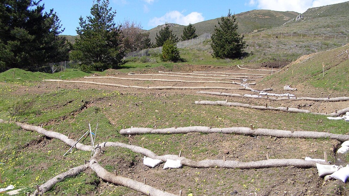
- Contour Terracing and Grassed Waterways: Constructing earthen berms along topographic contours breaks hillslope runoff velocity, conveying water harmlessly through wide, grass-lined swales that halt gully formation.
In urbanized catchments, Green Stormwater Infrastructure (GSI) and Low Impact Development (LID)—including permeable pavements, bioretention rain gardens, green roofs, and bioswales—infiltrate stormwater on-site, restoring natural pre-development hydrology and cleansing urban runoff.
6. Policy Frameworks: TMDLs, Water Quality Trading, and Catchment Governance
Technical engineering and agronomic BMPs are ineffective without robust institutional, legal, and economic policy frameworks to drive catchment-wide implementation. In the United States, the primary regulatory mechanism governing impaired watersheds is the Total Maximum Daily Load (TMDL) program mandated under Section 303(d) of the Clean Water Act.
A TMDL establishes the maximum cumulative amount of a specific pollutant (e.g., phosphorus, nitrogen, or sediment) that a water body can receive daily while still meeting legally enforceable state water quality standards: TMDL = sum(WLA) + sum(LA) + MOS, where WLA is the Waste Load Allocation for permitted industrial/municipal point sources, LA is the Load Allocation for diffuse non-point sources and natural background, and MOS is an explicit Margin of Safety accounting for scientific uncertainty.
To incentivize cost-effective compliance, progressive river basins are pioneering market-based Water Quality Trading (WQT) systems. In a typical WQT framework, a municipal wastewater treatment plant facing hundreds of millions of dollars in capital costs to achieve incremental nutrient reductions can purchase equivalent, certified nutrient reduction credits from upstream agricultural farmers who implement low-cost conservation BMPs (such as cover crops or constructed wetlands). Because reducing a pound of agricultural nutrient runoff often costs one-fifth to one-tenth the expense of advanced wastewater chemical filtration, water quality trading achieves catchment-wide compliance at dramatically lower societal cost.
Ultimately, successful watershed governance hinges on participatory stakeholder collaboration: uniting agricultural cooperatives, municipal water authorities, indigenous communities, conservation land trusts, and industrial stakeholders into formal River Basin Commissions. By aligning ecological physics with socioeconomic policy, Integrated Watershed Management provides the indispensable roadmap for sustaining humanity’s vital freshwater lifelines through the 21st century and beyond.