ICE AGE LANDSCAPE ATLAS · GLACIAL GEOLOGY
How Moving Ice Carved Two Famous Lake Landscapes
Discover how enormous ice sheets and mountain glaciers reshaped the land, deepened valleys, and left behind some of the world’s most recognizable lakes.
Some of the world’s most beautiful lake landscapes were shaped by forces that moved incredibly slowly.
Across thousands of years, enormous masses of ice advanced over mountains, valleys, and plains, gradually changing the surface of the Earth.
When the climate warmed and the ice retreated, deep basins and valleys remained behind.
Many of these depressions eventually filled with water, forming lakes.
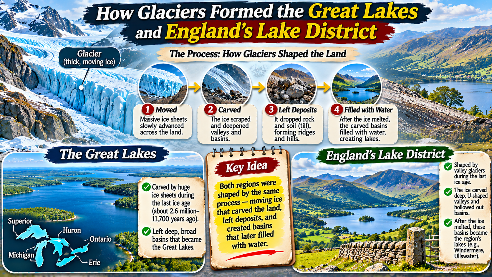
Two famous examples are the Great Lakes of North America and England’s Lake District.
Although these regions are separated by the Atlantic Ocean and differ greatly in scale, both preserve remarkable evidence of glacial activity.
Glaciers helped create these landscapes through erosion, sediment movement, and changes to natural drainage systems.
Understanding their formation reveals how the Ice Age continues to influence the geography we see today.
What Is a Glacier?
A glacier is a large, persistent mass of ice formed from accumulated snow that becomes compressed over time.
As additional snow builds up, lower layers gradually transform into dense glacial ice.
Under the influence of gravity, the ice begins to move.
Glaciers can flow through mountain valleys or spread across enormous continental areas.
Mountain glaciers are generally confined by surrounding topography.
Ice sheets cover much larger regions and can extend across landscapes containing mountains, valleys, and plains.
During the last glacial period, large parts of North America and northern Europe were covered by ice.
These ice masses changed the land through erosion, deposition, and the redistribution of water.
How Glaciers Change the Landscape
Glaciers reshape terrain primarily through erosion and deposition.
Erosion removes and transports rock and sediment.
Deposition occurs when glaciers release the material they have carried.
Several processes are especially important in creating lake landscapes.
Abrasion: Ice Grinding Against Rock
Glaciers often carry rocks and sediment within their ice.
As the glacier moves, this material can scrape against the underlying bedrock.
The process is called abrasion.
Over long periods, abrasion smooths rock surfaces, produces scratches known as striations, and contributes to the deepening of valleys and basins.
Plucking: Removing Blocks of Bedrock
Glacial plucking occurs when ice freezes onto fractured rock and helps pull pieces away as the glacier moves.
This process can enlarge depressions and create steep rock faces.
Plucking is particularly effective where bedrock contains joints or fractures.
Deposition: Leaving Sediment Behind
Glaciers transport material ranging from fine sediment to large boulders.
When the ice melts, it releases this material.
Deposits may form ridges called moraines.
Moraines can influence drainage by blocking valleys or helping retain water in depressions.
GLACIAL GEOMORPHOLOGY / THREE MAIN PROCESSES
Rock fragments carried by ice scrape and grind the underlying surface.
Moving ice removes fractured blocks of bedrock.
Melting ice releases sediment and creates features such as moraines.
How the Great Lakes Were Formed
The Great Lakes consist of Superior, Michigan, Huron, Erie, and Ontario.
Together, they form one of the world’s largest systems of freshwater lakes by surface area.
Their formation involved both ancient geological structures and powerful glacial processes.
The basins did not begin as completely featureless ground.
Differences in bedrock, pre-existing valleys, and geological structures helped influence where the lakes developed.
During repeated glaciations, ice sheets advanced across the region and modified these earlier landscapes.
The Laurentide Ice Sheet was especially important during the most recent glacial period.
As the ice moved, it eroded bedrock and sediment, deepening and reshaping large basins.
When the climate warmed and the ice retreated, meltwater accumulated in the depressions.
Changing ice margins, drainage routes, and land levels influenced the development of the modern Great Lakes.
The Role of the Laurentide Ice Sheet
The Laurentide Ice Sheet covered much of northern North America during the last glacial period.
At its greatest extent, it spread across large areas of present-day Canada and parts of the northern United States.
The ice was thick enough in many places to exert enormous pressure on the underlying landscape.
Its movement eroded existing depressions and transported vast quantities of sediment.
As the ice sheet began retreating, large volumes of meltwater were released.
Some meltwater collected between the retreating ice margin and higher ground.
This produced a series of changing proglacial lakes.
Over time, shifting outlets and the continued retreat of the ice helped establish the modern drainage system.
The Great Lakes therefore developed through a complex sequence rather than one single event.
Why the Great Lakes Have Different Shapes and Depths
Each Great Lake occupies a basin with its own geological history.
Lake Superior is exceptionally deep and occupies a region influenced by ancient geological structures and extensive glacial erosion.
Lakes Michigan and Huron occupy large interconnected basins.
Lake Erie is comparatively shallow.
Lake Ontario occupies a deeper basin shaped by bedrock conditions and glacial activity.
These differences reflect variations in underlying geology, erosion, sediment deposition, and drainage development.
Glaciers did not carve every part of the region equally.
Some rock types and geological structures were more vulnerable to erosion than others.
As a result, the lakes developed different depths, shorelines, and basin shapes.
How England’s Lake District Was Formed
England’s Lake District is a mountainous region in Cumbria known for its steep valleys, rugged fells, and long, narrow lakes.
Its landscape developed through a combination of ancient geological processes and repeated glaciation.
The mountains and bedrock existed long before the last Ice Age.
However, glaciers substantially reshaped the region.
During colder periods, ice accumulated in upland areas and flowed through valleys.
These glaciers eroded valley floors and sides, creating broad troughs and deep basins.
When the ice melted, water collected in some of the overdeepened valleys.
Other lakes were influenced by glacial deposits that helped obstruct drainage.
The result was a landscape containing long ribbon lakes, steep-sided valleys, and distinctive glacial landforms.
Why the Lake District Has U-Shaped Valleys
One of the clearest signs of glacial erosion is a U-shaped valley.
Rivers commonly erode valleys with relatively narrow, V-shaped cross sections.
When a large glacier occupies a valley, ice can erode both its floor and sides.
Over time, the valley may become wider and deeper.
The resulting cross section often resembles a broad U.
Many valleys in the Lake District show this characteristic form.
Glacial erosion also produced steep valley walls, truncated spurs, and other recognizable features.
Some valleys became deep enough to hold substantial bodies of water after the ice disappeared.
LANDSCAPE READING / VALLEY SHAPES
Rivers Often Carve V-Shaped Valleys. Glaciers Can Transform Them into U-Shaped Troughs.
The broad valley floors and steep sides found in many mountain landscapes are important evidence of past glacial erosion.
Ribbon Lakes: A Signature of the Lake District
Many Lake District lakes are long and relatively narrow.
These are often called ribbon lakes.
They commonly occupy glacially overdeepened valleys.
As glaciers moved through valleys, erosion was not uniform.
Some sections were deepened more strongly than others because of differences in bedrock, ice movement, and valley geometry.
After the glaciers retreated, water collected in these deeper sections.
Windermere, Ullswater, and Wast Water are well-known examples of lakes associated with glacially modified valleys.
Their elongated shapes reflect the directions of the valleys through which ice once flowed.
Unlike the enormous Great Lakes, these lakes are strongly controlled by mountainous topography.
How Moraines Helped Shape Lake Basins
Glaciers carry large amounts of rock debris.
When the ice melts, this material can accumulate in ridges or irregular deposits.
These deposits are known as moraines.
Some moraines form along glacier margins.
Others develop near the end of a glacier or beneath moving ice.
In certain valleys, deposited sediment can restrict water flow.
This may contribute to the formation or persistence of a lake.
However, not every glacial lake is primarily dammed by a moraine.
Many occupy basins excavated directly into bedrock.
Both erosion and deposition must be considered when explaining a particular lake’s origin.
The Ice Age Timeline: From Glaciers to Lakes
GLACIAL HISTORY / SIMPLIFIED FORMATION SEQUENCE
Persistent cold conditions allow snow to build up and transform into glacial ice.
Gravity causes glaciers and ice sheets to move across the landscape.
Abrasion and plucking deepen and reshape existing geological features.
Warming conditions cause glaciers to shrink, leaving behind sediment and depressions.
Meltwater and later precipitation collect in suitable depressions, forming lakes.
Great Lakes vs. Lake District: Key Differences
| Feature | Great Lakes | England’s Lake District |
|---|---|---|
| Location | North America | Northwest England |
| Main ice influence | Continental ice sheets | Ice sheets and valley glaciers |
| Typical lake scale | Very large basins | Smaller mountain and valley lakes |
| Landscape character | Broad basins and extensive shorelines | Steep mountains and narrow valleys |
| Important processes | Glacial erosion, retreat, drainage changes | Valley erosion, overdeepening, deposition |
| Recognizable features | Large freshwater lakes | Ribbon lakes and U-shaped valleys |
Why the Landscapes Continued Changing After the Ice Melted
The retreat of glaciers did not mark the end of landscape development.
During glaciation, the enormous weight of ice depressed parts of Earth’s crust.
After the ice disappeared, the crust began gradually rising.
This process is called glacial isostatic adjustment.
It continues in some formerly glaciated regions today.
Changes in land elevation can influence lake shorelines, drainage patterns, and water levels.
Rivers also continue to transport sediment into lakes.
Waves reshape shorelines, while weathering and erosion alter surrounding slopes.
In the Lake District, streams and hillslope processes continue modifying valleys originally shaped by ice.
In the Great Lakes region, shoreline processes and changing drainage conditions remain important.
How Scientists Know Glaciers Were Responsible
Geologists identify evidence of past glaciers through landforms, sediments, and rock surfaces.
Glacial striations are scratches produced when rock fragments embedded in moving ice scrape against bedrock.
Moraines reveal where glaciers deposited sediment.
U-shaped valleys indicate extensive valley modification by moving ice.
Erratics are rocks transported by glaciers and deposited far from their original geological source.
Scientists also examine sediment layers and geological records to reconstruct the timing of glacial events.
By combining these clues, researchers can estimate former ice movement and understand how lake basins developed.
Why These Glacial Lakes Matter Today
The Great Lakes provide freshwater resources, transportation routes, and important habitats.
They support communities, industries, fisheries, and recreation across the United States and Canada.
England’s Lake District is internationally recognized for its mountain scenery, lakes, cultural landscapes, and recreational opportunities.
Its glacial landforms are also valuable for understanding Earth’s environmental history.
Both regions demonstrate how geological events from thousands of years ago continue to shape human activities and natural ecosystems.
They also remind us that landscapes are not permanent.
They develop through ongoing interactions among climate, rock, ice, water, and time.
Frequently Asked Questions
Did glaciers create the Great Lakes?
Glaciers played a major role in shaping and deepening the basins, although pre-existing geological structures also influenced their formation.
Which ice sheet shaped the Great Lakes?
The Laurentide Ice Sheet was particularly important during the most recent glacial period.
How did glaciers form lakes in England’s Lake District?
Glaciers eroded and deepened mountain valleys. After the ice retreated, water accumulated in suitable depressions.
What is a ribbon lake?
A ribbon lake is a long, narrow lake commonly occupying a glacially overdeepened valley.
What is a U-shaped valley?
It is a broad valley with a relatively flat floor and steep sides, often formed or enlarged by glacial erosion.
What is a moraine?
A moraine is an accumulation of rock debris and sediment deposited by a glacier.
Are glacial landscapes still changing?
Yes. Erosion, sediment deposition, changing drainage patterns, and glacial isostatic adjustment continue to influence some formerly glaciated regions.
Final Thoughts
The Great Lakes and England’s Lake District demonstrate the extraordinary ability of glaciers to reshape Earth’s surface.
In North America, continental ice sheets modified enormous geological basins that eventually became the Great Lakes.
In England, glaciers transformed mountain valleys into broad troughs and deep depressions that later filled with water.
Although the two regions differ in size and landscape character, both preserve evidence of abrasion, plucking, sediment deposition, and changing drainage systems.
Their lakes are lasting reminders of a time when ice covered much larger portions of the planet.
By studying these landscapes, scientists can reconstruct past climates and understand how geological processes shape the world.
What appears today as peaceful lakes and scenic mountains is the result of enormous forces acting over thousands of years.