RIVER GEOGRAPHY ATLAS / LANDFORMS & WATER SYSTEMS
How a Winding River Reshapes the Land Around It
Explore why rivers develop sweeping bends, how flowing water creates oxbow lakes, and why the Mississippi River is a remarkable example of a changing landscape.
Look at an aerial photograph of the lower Mississippi River, and one feature becomes immediately obvious: the river rarely follows a perfectly straight path.
Instead, it curves across broad floodplains in sweeping bends.
Some bends resemble giant loops, while others appear as abandoned channels or crescent-shaped lakes beside the modern river.
These features are not random.
They develop through the continuous interaction of flowing water, sediment, erosion, and deposition.
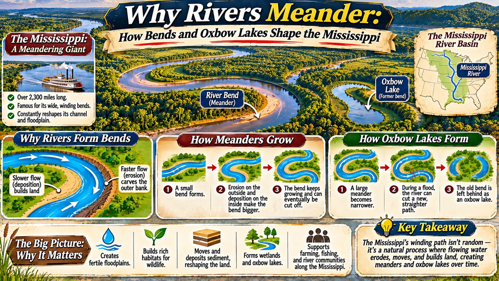
River bends are called meanders, and abandoned bends that become separated from the main channel can form oxbow lakes.
The Mississippi River provides one of North America’s most recognizable examples of these processes.
Understanding how meanders form helps explain why river channels migrate, how floodplains develop, and why landscapes beside large rivers can change over time.
What Is a River Meander?
A meander is a curved section of a river channel.
Meanders are common in rivers flowing across relatively gentle slopes, particularly where the channel can erode its banks and move across a floodplain.
Rather than flowing directly downhill in a straight line, water follows a winding route.
Meanders develop because the movement of water and sediment varies across the channel.
Flow is not identical along the inside and outside of a bend.
These differences influence where sediment is removed and where it accumulates.
Over time, repeated erosion and deposition can enlarge and shift the bends.
Although many people associate meanders with large rivers, smaller streams can also develop winding channels.
Why Rivers Begin to Curve
Natural river channels rarely have perfectly uniform banks, sediment, or flow conditions.
Small differences in channel shape can influence the direction and speed of moving water.
Once a slight bend develops, the flow pattern around it can encourage additional erosion and deposition.
Water moving through a curve experiences changes in momentum and pressure.
These changes create complex circulation patterns within the channel.
Near the outside of a bend, relatively strong flow can erode the bank.
Near the inside, slower-moving water may allow sediment to accumulate.
This combination helps the bend grow and migrate.
The process is influenced by river discharge, sediment supply, bank materials, vegetation, and valley conditions.
Erosion on the Outside of a Bend
The outside of a meander often experiences stronger bank erosion.
This location is commonly called the cut bank.
Flow patterns concentrate erosive forces against the outer bank.
As sediment is removed, the bank may become steep or unstable.
Sections of the bank can collapse into the river.
Over time, repeated erosion shifts the outer edge of the channel.
Bank erosion is a natural part of river movement, although it can threaten nearby roads, farmland, and buildings.
The rate of erosion varies greatly depending on soil composition, vegetation, water levels, and other conditions.
Deposition on the Inside of a Bend
While the outer bank may erode, sediment often accumulates along the inside of the bend.
This feature is called a point bar.
Point bars form where the river deposits sand, gravel, and other sediment.
As material builds up, the inner bank may gradually extend into the channel.
Vegetation can eventually establish itself on exposed deposits.
Over time, these deposits may become part of the surrounding floodplain.
The combination of erosion outside the bend and deposition inside the bend helps the meander migrate across the landscape.
RIVER SCIENCE / TWO SIDES OF A BEND
Outer Bend: Erosion. Inner Bend: Deposition.
This simplified pattern helps explain why many meanders grow and shift, although actual river flow and sediment movement are more complex.
How Meanders Move Across Floodplains
Meanders are not necessarily permanent features.
As erosion and deposition continue, bends may gradually change position.
Some migrate sideways across the floodplain.
Others extend downstream or become increasingly curved.
Over long periods, this movement can leave visible traces in the landscape.
Former channel positions may appear as curved depressions, abandoned water bodies, or subtle differences in vegetation and soil.
These patterns are sometimes called meander scars.
They provide evidence of earlier river positions.
In the Mississippi River floodplain, old channel traces reveal that the river has occupied different routes over time.
What Is an Oxbow Lake?
An oxbow lake is a curved body of water formed when a river bend becomes separated from the main channel.
Its shape often resembles a horseshoe or crescent.
Oxbow lakes are especially associated with meandering rivers on broad floodplains.
They form when a river establishes a shorter route across the narrow land separating two parts of a meander.
The old bend becomes abandoned as the main flow moves through the new channel.
Sediment deposition can gradually close the entrances to the abandoned bend.
The remaining water body becomes an oxbow lake.
How an Oxbow Lake Forms: Step by Step
RIVER LANDFORM / FORMATION SEQUENCE
Flowing water erodes the outside of a bend and deposits sediment along the inside.
Continued channel migration can bring two sections of the river closer together.
The river establishes a shorter route across the narrow neck of land, sometimes during high flows.
Most of the river’s flow follows the new channel, leaving the former loop with much less current.
Sediment can close the abandoned channel entrances, creating a separate curved water body.
Why the Mississippi River Has So Many Meanders
The lower Mississippi River flows through a broad alluvial valley.
Much of this landscape contains sediments deposited by the river and its tributaries over long periods.
The relatively gentle regional slope and erodible materials provide conditions in which channel migration can occur.
Historically, the river shifted across portions of its floodplain, creating bends, abandoned channels, and other sedimentary landforms.
Its enormous drainage basin supplies water and sediment from a large part of North America.
These factors contribute to the Mississippi’s complex channel history.
However, modern engineering has altered many natural processes along the river.
Levees, bank stabilization, navigation structures, and other projects influence flooding, sediment movement, and channel behavior.
Oxbow Lakes Along the Mississippi
The Mississippi River floodplain contains numerous former channel features.
Some abandoned bends remain filled with water, while others have gradually accumulated sediment and vegetation.
These features can be seen in aerial imagery and topographic maps.
Lake Chicot in Arkansas is a well-known example of a large oxbow lake associated with an earlier course of the Mississippi River.
Its curved shape reflects the river’s former channel geometry.
Such lakes provide valuable evidence of how major rivers have changed their courses over time.
They also create distinctive aquatic and wetland environments.
How Meanders Build and Reshape Floodplains
A floodplain is a relatively flat area beside a river that may be inundated during high water.
Meandering rivers contribute to floodplain development through erosion and sediment deposition.
Point bars add sediment along the inside of bends.
Floodwaters may spread fine sediment across nearby land.
Abandoned channels can gradually fill with mud and organic material.
Over time, these processes create a complex landscape of ridges, depressions, wetlands, and former river courses.
Floodplains can provide productive soils and important wildlife habitats.
However, they are also exposed to flooding and channel-related hazards.
Why Oxbow Lakes Matter for Wildlife
Oxbow lakes can support a variety of aquatic and wetland species.
Because they are often separated from the main river channel, their water conditions may differ from those of the flowing river.
Some provide habitat for fish, amphibians, aquatic plants, insects, and waterbirds.
Vegetation along their margins can offer shelter and feeding areas.
Seasonal flooding may reconnect certain oxbow lakes with the river, allowing water, sediment, nutrients, and organisms to move between habitats.
Over time, sediment accumulation and plant growth can gradually transform some oxbow lakes into wetlands or other floodplain environments.
These changes are part of the natural evolution of river landscapes.
How River Engineering Changes Meander Movement
Large rivers such as the Mississippi are important for navigation, agriculture, transportation, and nearby communities.
Engineers have constructed levees, revetments, and other structures to manage flooding and stabilize certain channel sections.
Bank protection can reduce erosion at selected locations.
Navigation improvements may also influence channel shape and flow patterns.
These interventions can provide important benefits, but they also alter natural river processes.
Reducing channel migration may change sediment deposition and the creation of new floodplain habitats.
River management therefore involves balancing economic needs, public safety, and ecological considerations.
Meanders vs. Oxbow Lakes: Key Differences
| Feature | River Meander | Oxbow Lake |
|---|---|---|
| Definition | A curved section of an active river channel | An abandoned bend separated from the main channel |
| Water Movement | Part of the river’s main flow | Usually much slower or relatively still |
| Formation | Channel erosion and deposition | Meander cutoff and channel abandonment |
| Typical Shape | Winding river curve | Crescent or horseshoe-shaped water body |
| Long-Term Change | May migrate or become cut off | May fill with sediment and become wetland |
How to Recognize Old River Channels on a Map
Modern satellite images provide an accessible way to study meandering rivers.
Look for curved channels, crescent-shaped lakes, and abandoned bends beside the active river.
Some former channels appear as darker strips of vegetation or low-lying land.
Others remain visible as shallow depressions.
Historic maps can reveal how channel positions have changed over time.
Comparing maps from different periods helps researchers identify migration patterns and areas where cutoffs occurred.
However, interpreting old channels requires care because lakes and curved landforms can develop through other processes as well.
Frequently Asked Questions
Why do rivers meander instead of flowing straight?
Differences in flow, bank erosion, and sediment deposition can cause bends to develop and migrate, especially in rivers crossing relatively gentle terrain.
What causes an oxbow lake to form?
An oxbow lake forms when a river cuts across a narrow meander neck, abandons the old loop, and sediment gradually separates it from the main channel.
Does the Mississippi River have oxbow lakes?
Yes. Its floodplain contains numerous abandoned channels and oxbow lakes, including Lake Chicot in Arkansas.
What is a cut bank?
A cut bank is the outer side of a river bend where erosion commonly removes sediment from the bank.
What is a point bar?
A point bar is a sediment deposit that commonly develops along the inside of a meander bend.
Can oxbow lakes disappear?
Yes. Sediment accumulation and vegetation growth can gradually transform oxbow lakes into wetlands or other floodplain environments.
Do meanders increase flood risk?
Meandering rivers can experience bank erosion and flooding, but flood risk depends on many factors, including river discharge, topography, weather, and floodplain management.
Final Thoughts
River meanders form through the ongoing interaction of flowing water, erosion, and sediment deposition.
As bends migrate, they reshape riverbanks and surrounding floodplains.
When a river establishes a shorter route across a meander neck, the abandoned bend may become an oxbow lake.
The Mississippi River illustrates these processes on an enormous scale.
Its floodplain preserves evidence of earlier channels, abandoned bends, and changing river positions.
These landforms influence habitats, agriculture, navigation, and floodplain management.
Understanding meanders and oxbow lakes reveals that rivers are not fixed lines on a map.
They are dynamic systems that continually shape the landscapes through which they flow.