LANDSCAPE HYDROLOGY ATLAS · RIVERS & RAINFALL
Following a Raindrop from Hillside to River
Discover how watersheds collect and move rainfall, why drainage divides matter, and how rivers connect landscapes across the United States and United Kingdom.
When rain falls on a hillside, where does the water go?
Some of it flows across the ground. Some soaks into soil, and some may eventually reach streams, rivers, lakes, or the sea.
The route depends on the shape of the land, the properties of the soil, the underlying geology, and the amount of rainfall.
Although water appears to move in countless directions, landscapes are organized into natural drainage areas.
These areas are called watersheds or drainage basins.
Understanding watersheds helps explain why rivers form where they do, how flooding develops, and why activities far upstream can affect communities downstream.
A watershed connects rainfall, landforms, groundwater, streams, and rivers into one interacting system.
From the Appalachian Mountains to the hills of Wales, the same basic hydrological principles shape how water moves through the landscape.
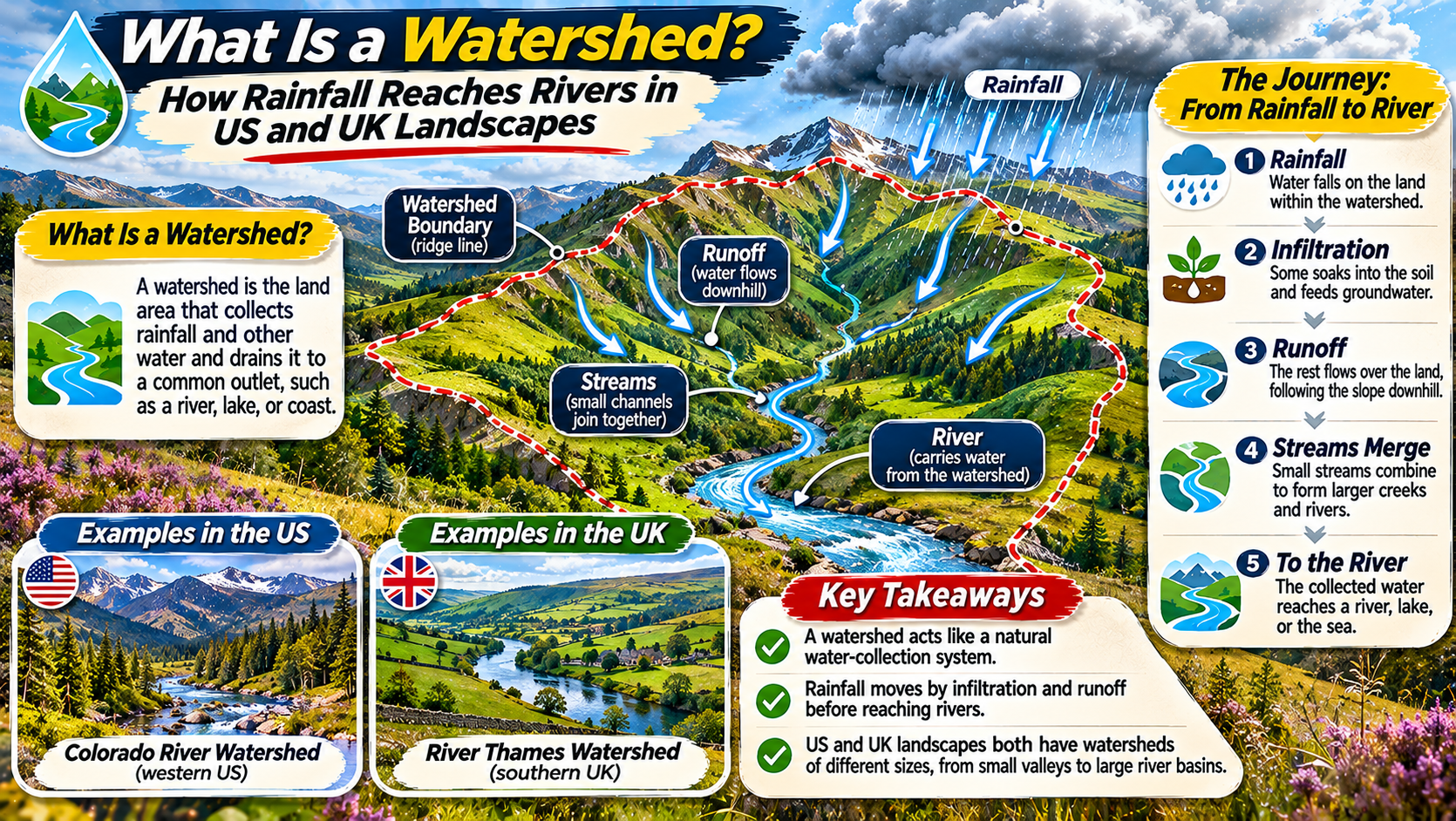
What Is a Watershed?
In American hydrology, a watershed is an area of land where water drains toward a shared outlet.
That outlet might be a stream, river, lake, reservoir, estuary, or another water body.
Rainfall and snowmelt within the watershed can contribute to the connected drainage system.
The boundaries of a watershed are generally determined by the surrounding topography.
Ridges and higher ground separate neighboring drainage areas.
Water falling on one side of a ridge may enter one river system, while water falling on the opposite side may enter another.
Watersheds can be very small or extremely large.
A small stream may drain a few fields or neighborhoods.
A major river system can collect water from an area spanning multiple states or regions.
Watershed vs. Drainage Basin: US and UK Terminology
The terms watershed and drainage basin are closely related, but their usage differs between countries.
In the United States, watershed commonly means the entire land area draining to a particular outlet.
In British geographical usage, drainage basin or river basin is often used for that same concept.
In some UK educational contexts, watershed refers specifically to the high ground or boundary separating adjacent drainage basins.
This boundary is also called a drainage divide.
Both usages are established, so context matters.
When reading an American environmental report, watershed will usually refer to the whole drainage area.
When studying British school geography, watershed may describe the dividing line between river basins.
GEOGRAPHY TERMINOLOGY NOTE
One Landscape Concept, Two Common Ways of Using the Word “Watershed.”
US: Watershed usually means the area draining to a common outlet.
UK: Drainage basin commonly means that area, while watershed may refer to the dividing ridge between basins.
How Rainfall Moves Through a Watershed
Rainfall does not follow one universal route to a river.
Instead, water moves through several pathways depending on the conditions it encounters.
Some rain is intercepted by leaves and branches before reaching the ground.
Some water evaporates back into the atmosphere.
Water reaching the soil may infiltrate and move through underground layers.
When rainfall exceeds the ground’s ability to absorb water, surface runoff may develop.
These pathways interact to determine how quickly streams and rivers respond to rainfall.
HYDROLOGICAL FLOW / FROM RAIN TO RIVER
Rain or snow reaches the landscape.
Vegetation catches some water, while another portion enters the soil.
Water travels over land or through soil and groundwater pathways.
Water enters small channels and tributaries.
Connected channels carry water toward the watershed’s outlet.
Surface Runoff: When Water Flows Over the Land
Surface runoff occurs when water travels across the ground rather than entering the soil.
One cause is rainfall arriving faster than the soil can absorb it.
Runoff can also develop when soil becomes saturated and has little remaining capacity to store additional water.
Steep slopes may encourage water to move quickly downhill.
Compacted soils, paved surfaces, and some land-use changes can increase runoff.
As runoff collects, it may enter small depressions, ditches, streams, and rivers.
Rapid runoff can cause river levels to rise quickly during heavy rainfall.
This is one reason intense storms can produce flash flooding in certain watersheds.
Infiltration: How Water Enters the Soil
Infiltration is the process by which water enters the soil surface.
Its rate depends on soil texture, structure, moisture, vegetation, and other factors.
Some sandy soils allow water to enter relatively quickly.
Clay-rich soils may absorb water more slowly, although soil structure can greatly affect the result.
Plant roots and soil organisms can create pathways that help water move into the ground.
Once inside the soil, water may be stored temporarily, taken up by plants, or move deeper.
Some of it travels sideways through soil layers toward streams.
This subsurface movement can contribute to river flow even when little surface runoff is visible.
Groundwater and the Hidden Connection to Rivers
Groundwater is water stored in the saturated spaces of soil and rock beneath Earth’s surface.
It forms an important part of many watershed systems.
Rainwater may percolate downward and recharge underground water stores.
Groundwater can then move slowly through permeable materials.
In some locations, groundwater flows into streams and rivers.
This contribution helps maintain river flow during periods without rainfall.
Hydrologists often refer to the sustained component of river flow as baseflow.
However, the relationship between groundwater and rivers varies.
Some rivers gain water from surrounding groundwater, while others lose water into the ground.
Understanding these interactions is important for managing water supplies and protecting river ecosystems.
What Is a Drainage Divide?
A drainage divide is a boundary separating neighboring drainage basins.
It often follows ridges, hilltops, or other areas of relatively high ground.
Rain falling on opposite sides of the divide may travel toward different rivers.
In mountainous regions, divides can be easy to recognize because they follow prominent ridgelines.
In flatter landscapes, they may be subtle and difficult to identify without elevation data.
Surface-water divides and groundwater divides do not always coincide exactly.
Underground geological structures can direct groundwater along pathways that differ from surface drainage.
This is one reason watershed analysis may require both topographic and geological information.
Tributaries: How Small Streams Build Large Rivers
A tributary is a stream or river that flows into a larger watercourse.
Most major rivers receive water from many tributaries.
These smaller channels collect runoff and subsurface contributions from different parts of the watershed.
As tributaries join, the drainage network becomes larger.
Rainfall in one part of the basin may reach the main river quickly.
Water from another area may take much longer.
Travel time depends on slope, distance, soil conditions, channel characteristics, and other factors.
The combined response of many tributaries influences how river levels change during storms.
How Watershed Shape Influences Flooding
Watersheds vary in size and shape.
Some are long and narrow, while others are relatively compact.
These differences can affect how quickly water reaches a common outlet.
In a compact basin, runoff from different areas may arrive within a shorter time window under certain storm conditions.
In an elongated basin, water from distant parts may arrive more spread out over time.
However, shape is only one factor.
Rainfall intensity, storm movement, soil saturation, vegetation, drainage networks, and land use also influence flood response.
Engineers and hydrologists study these variables together when evaluating flood risk.
Example: The Mississippi River Basin in the United States
The Mississippi River basin is one of North America’s largest drainage systems.
It collects water from a vast region of the central United States.
Major tributaries include the Missouri, Ohio, Arkansas, and Red rivers.
Rainfall and snowmelt from distant landscapes can eventually contribute to the Mississippi River system.
Water moving through the basin may pass through streams, rivers, reservoirs, wetlands, and groundwater systems.
Because the drainage area is so large, conditions in one region can influence downstream water levels and water quality.
The basin illustrates how watersheds connect places that may be hundreds or thousands of miles apart.
Example: The River Thames Basin in the United Kingdom
The River Thames drains a large area of southern England.
Its basin includes rural landscapes, towns, and major urban areas.
Rainfall enters the river system through tributaries, surface runoff, and groundwater contributions.
Geology plays an important role in parts of the basin.
Chalk and other permeable formations can store and transmit groundwater.
Urban development also affects how quickly rainfall reaches drainage systems and watercourses.
The Thames basin demonstrates the importance of understanding both natural processes and human influences.
It also shows why river management must consider conditions across the entire drainage area rather than only the main channel.
US and UK Watershed Landscapes Compared
| Feature | United States | United Kingdom |
|---|---|---|
| Common term | Watershed | Drainage basin or river basin |
| Example | Mississippi River basin | River Thames basin |
| Landscape variety | Mountains, plains, deserts, forests | Uplands, lowlands, valleys, urban areas |
| Major influences | Regional climate, snowmelt, storms, land use | Rainfall, geology, soil saturation, land use |
| Management concerns | Flooding, water quality, drought, habitat | Flooding, water quality, abstraction, habitat |
How Forests, Wetlands, and Grasslands Affect Water Flow
Vegetation influences how rainfall moves through a watershed.
Tree canopies intercept some precipitation.
Roots and soil organisms can improve soil structure and create pathways for infiltration.
Wetlands may temporarily store water and influence the timing of downstream flows.
Grasslands and other vegetated areas can reduce soil erosion under suitable conditions.
However, the effects of vegetation vary with rainfall intensity, soil type, season, and landscape characteristics.
Forests and wetlands do not eliminate flooding.
Instead, they can influence how water is stored, released, and transported through a drainage basin.
How Cities Change Watershed Behavior
Urban development can significantly alter natural drainage patterns.
Roads, roofs, parking areas, and other impermeable surfaces reduce opportunities for rainfall to infiltrate into the ground.
Storm drains and engineered channels may move water rapidly toward nearby streams.
This can increase the speed of runoff during heavy rainfall.
Urban areas may also introduce pollutants into watercourses through runoff.
To address these challenges, some communities use rain gardens, permeable paving, detention basins, and other sustainable drainage measures.
Such approaches aim to manage water closer to where it falls.
Their effectiveness depends on design, maintenance, local geology, and storm conditions.
Why Watershed Management Matters
Watershed management considers the connected effects of land use, water movement, ecosystems, and human activities.
Actions upstream can influence downstream conditions.
For example, soil erosion may increase sediment entering streams.
Fertilizers and other pollutants can move through runoff and drainage pathways.
Changes in vegetation and land cover may affect infiltration and runoff.
Watershed-based planning helps communities examine these issues across the entire drainage area.
This approach supports water quality protection, flood-risk management, habitat conservation, and sustainable water use.
It also encourages cooperation between communities sharing the same river system.
How to Identify a Watershed on a Map
A topographic map provides useful clues about watershed boundaries.
Contour lines show changes in elevation.
Ridges and high ground often mark the boundaries between neighboring drainage areas.
Streams generally flow downhill, and tributaries join to form larger channels.
To identify a watershed, begin with a chosen river outlet.
Then trace the surrounding high ground that separates water flowing toward that outlet from water draining elsewhere.
Digital elevation models and geographic information systems can perform this analysis more precisely.
However, even a simple topographic map can help explain the basic relationship between slopes, divides, and river networks.
Frequently Asked Questions
What is a watershed in simple terms?
In common US usage, a watershed is an area of land where water drains toward the same stream, river, lake, or other outlet.
Is a watershed the same as a drainage basin?
In American usage, the terms are often interchangeable. In British geography, watershed may instead refer to the dividing boundary between drainage basins.
How does rainfall reach a river?
Rainfall can reach rivers through surface runoff, movement through soil, groundwater discharge, and connected stream channels.
What separates two watersheds?
A drainage divide, often following higher ground, separates neighboring surface drainage areas.
Does all rainfall in a watershed reach the river?
No. Some water evaporates, is used by vegetation, remains stored in soil or groundwater, or follows other pathways.
Why do watersheds matter for flooding?
Watershed size, shape, slopes, soils, rainfall, and land use influence how quickly water reaches rivers and how river levels respond.
Can cities change natural watersheds?
Yes. Urban development can alter runoff pathways, infiltration, drainage speed, and water quality.
Final Thoughts
Watersheds reveal how water connects the landscape.
Rain falling on hills, fields, forests, and cities may eventually contribute to the same river system.
Some water moves quickly across the surface, while other water travels slowly through soil and groundwater.
Drainage divides separate neighboring basins, and tributaries collect water from different parts of the landscape.
These processes shape river flow, influence flood risk, and affect water quality.
Although the terminology differs between the United States and United Kingdom, the underlying hydrological principles are the same.
Understanding watersheds helps explain why river management must consider entire landscapes rather than isolated sections of water.
The next time rain falls, imagine the many possible routes each drop may follow.
Some of that water could eventually become part of a river flowing far beyond the place where the rain first landed.