1. The Anthropocene River: Global Overview of Human Modifications
Over the past two centuries of industrial expansion and population growth, the surface of planet Earth has entered an epoch in which human activity represents the dominant geological agent shaping fluvial landscapes. The alteration of natural river networks has reached unprecedented global proportions: of the world’s 246 longest rivers (greater than 1,000 kilometers in length), only 37% remain free-flowing from headwaters to ocean, with the overwhelming majority disrupted by impoundments, levee systems, trans-basin diversions, and urban channelization. The natural flow regimes that evolved over millions of years to dictate sediment routing, channel geometry, and freshwater biological life cycles have been systematically subdued in pursuit of hydroelectric power generation, agricultural irrigation, flood risk mitigation, and inland commercial navigation.
The consequences of these systemic modifications manifest across multiple spatial and temporal scales, altering the global water balance, sediment flux, and freshwater biodiversity. Globally, artificial impoundments currently trap more than 100 billion metric tons of sediment within reservoir basins—nearly 25% of the total annual sediment flux that previously sustained coastal delta complexes, marine estuaries, and barrier island systems worldwide. Consequently, catastrophic deltaic subsidence, coastal land loss, and coastal erosion are accelerating rapidly across the Nile, Mississippi, Colorado, Indus, and Mekong deltas, leaving coastal human populations and critical ecological biomes vulnerable to rising global sea levels and storm surges.
Furthermore, chemical alterations resulting from agricultural fertilizer runoff, municipal wastewater discharge, industrial heavy metal pollution, and pharmaceutical contaminants have severely degraded lotic water quality. The widespread loss of natural wetland floodplains and riparian vegetative buffers has eliminated the natural biochemical filtration capacities of river networks, driving massive downstream nutrient loading that fuels expansive oceanic hypoxic dead zones in the northern Gulf of Mexico, the Baltic Sea, and the East China Sea.
In urban landscapes, the hydrological phenomenon known as the ‘Urban Stream Syndrome’ has fundamentally transformed stream hydraulics. Widespread impervious surfaces (roads, rooftops, parking lots) eliminate soil infiltration, routing stormwater directly into streams via storm sewer networks. This triggers flashier, hyper-peaked storm hydrographs characterized by catastrophic peak discharges, followed by desiccated baseflows during dry intervals. The resulting high-velocity surges scour away stream gravels, erode channel banks, incise bedrock, and strip away benthic biological communities, rendering urban waterways sterile drainage chutes unless mitigated through green stormwater infrastructure.
💧 Geomorphological Concept: ‘Hungry Water’
When an alluvial river enters an artificial reservoir, water velocity approaches zero, forcing 90% to 99% of its sediment load to deposit behind the dam. Released water discharged downstream through spillways or hydroelectric turbines is virtually devoid of sediment. This clear, sediment-starved ‘hungry water’ possesses excess kinetic energy, driving intense downcutting, channel incision, and bridge pier scour for dozens of kilometers downstream.
2. Dam Hydraulics and the Alteration of Natural Flow Regimes
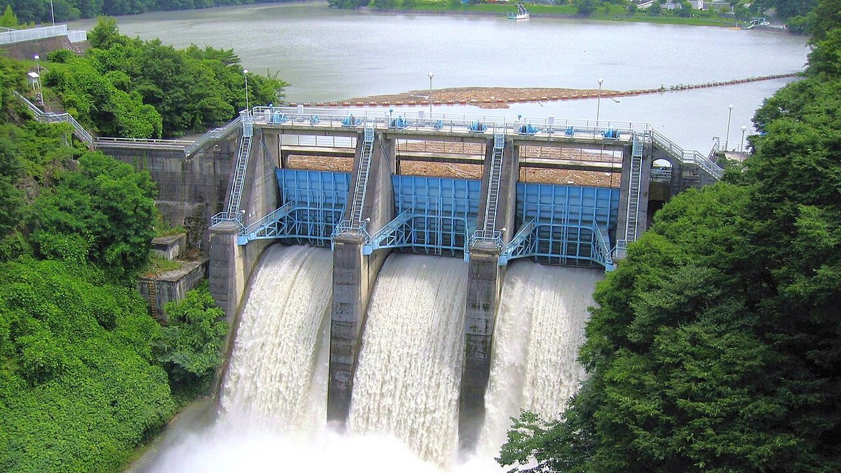
The construction of large dams fundamentally severs the three critical spatial axes of river ecosystems: the longitudinal axis (connecting upstream headwaters with downstream floodplains and deltas), the lateral axis (connecting the active channel with adjacent riparian backwaters), and the vertical axis (connecting surface flow with subterranean hyporheic aquifers). From an engineering perspective, dam operations introduce extreme hydraulic and thermal discontinuities that violate the natural continuum of river dynamics.
Thermal pollution represents a particularly insidious downstream consequence of deep hypolimnetic reservoir releases. Large storage dams establish pronounced thermal stratification during summer months, with a warm upper layer (epilimnion) floating atop a dense, frigid, anoxic bottom layer (hypolimnion). When hydroelectric turbines draw intake water from the deep hypolimnion, the water released downstream can be 10°C to 15°C colder than natural ambient summer stream temperatures. This artificial thermal shock disrupts the life cycles of native warm-water fish species, inhibiting gonadal maturation, suppressing egg hatching, and eradicating temperature-dependent macroinvertebrate emergence cues for hundreds of kilometers downstream.
Hydrologically, hydroelectric peaking operations (‘hydropeaking’) impose violent, artificial sub-daily discharge fluctuations. Rather than experiencing gradual, seasonal flood pulses, the tailwater river downstream of a hydropeaking facility undergoes rapid, multi-fold surges in water stage and velocity multiple times within a single 24-hour cycle to meet peak commercial electrical demands. This rapid surging repeatedly scours benthic macroinvertebrates, shears away periphytic biofilms, and strand juvenile fish in desiccating gravel bars during abrupt operational shutdowns.
In addition, reservoirs create severe biogeochemical disruptions within the impounded water body itself. Organic carbon, plant matter, and agricultural runoff washed into deep, warm, stratified reservoirs decompose under anaerobic conditions, fueling massive microbial methanogenesis. Large tropical hydropower dams, such as Balbina and Tucuruí in Brazil, emit millions of tons of methane (CH4)—a greenhouse gas with a warming potential over 28 times greater than carbon dioxide over a century—undermining the clean-energy profile of certain tropical hydroelectric projects.
| Anthropogenic Impact | Hydrological Mechanism | Geomorphological Manifestation | Ecological Consequence | Restoration Strategy |
|---|---|---|---|---|
| Large Storage Dams | Upstream sediment trapping & discharge regulation | Downstream channel incision & armor bed formation | Thermal pollution & fish migration barrier | Fish passage bypasses & controlled thermal releases |
| Channelization & Dredging | Straightening, deepening & concrete armoring | Loss of meanders, riffle-pool sequences & sinuosity | Elimination of low-velocity micro-habitats | Two-stage ditching & meander re-meandering |
| Agricultural Leveeing | Complete severance of channel from floodplain | Narrowed floodway & increased stage velocities | Starvation of floodplain wetlands of silt & seed | Levee setbacks & controlled seasonal inundation |
| Hydropeaking Facilities | Rapid sub-daily discharge ramping for peak power | Basal bank destabilization & scour cycles | Catastrophic stranding of juvenile fish & macroinvertebrates | Ramping rate restrictions & re-regulating weirs |
| Groundwater Over-extraction | Depletion of unconfined shallow alluvial aquifers | Perennial streams convert to intermittent/dry beds | Loss of hyporheic refugia & baseflow desiccation | Managed aquifer recharge & sustainable basin caps |
3. Channelization, Levees, and the Loss of Floodplain Connectivity
Channelization encompasses the physical, civil-engineering modification of natural river channels through straightening, widening, deepening, levee confinement, and bank armoring with riprap or concrete revetments. Historically pursued to accelerate drainage from agricultural lowlands, facilitate inland barge navigation, and protect floodplains from inundation, channelization treats the river as a conveyance pipe. However, by substituting complex natural planforms with uniform trapezoidal geometries, channelization triggers severe hydrologic and geomorphological repercussions.
Straightening a meandering river drastically reduces its overall channel length while maintaining the same vertical drop between points, thereby substantially increasing the channel’s energy slope (S). Because stream velocity (v) scales directly with slope via Manning’s equation (v = [1/n]·R^(2/3)·S^(1/2)), flow velocities surge dramatically. This accelerated velocity intensifies basal shear stress, initiating catastrophic bed degradation and upstream-migrating knickpoint erosion that destabilizes bridges, severs tributary connections, and lowers local water table elevations by several meters, desiccating surrounding agricultural soils.
Simultaneously, confining rivers within continuous earthen levees eliminates the natural sponge effect of alluvial floodplains. When overbank floodwaters can no longer spread across expansive floodplains to dissipate kinetic energy and infiltrate into aquifers, the entire volumetric discharge is compressed within a narrow, artificial chute. Consequently, flood crests become significantly narrower, steeper, and higher, dramatically increasing the catastrophic risk of levee breaches and catastrophic inundation in downstream urban centers, as witnessed during the monumental 1993 and 2011 Mississippi River floods.
The ecological consequence of this loss of lateral connectivity is catastrophic. Over 90% of native riverine fish species rely upon seasonally inundated floodplain backswamps for spawning, larval rearing, and foraging. Juvenile fish gain access to rich food supplies of zooplankton and chironomids thriving in warm, tranquil floodplain waters. When levees sever this connection, reproductive recruitment collapses, triggering the extirpation of native fish populations and transforming diverse river corridors into ecologically impoverished aquatic highways.
4. Environmental Flows: Science, Methods, and Implementation
In response to widespread fluvial degradation, freshwater scientists have formulated the discipline of Environmental Flows (E-Flows). Environmental flows describe the quantity, timing, and quality of freshwater flows and levels required to sustain freshwater ecosystems and the human livelihoods and well-being that depend upon them. Modern E-flow science rejects the outdated paradigm of static ‘minimum flow’ releases, recognizing that freshwater biodiversity and channel geomorphology are intrinsically adapted to the natural dynamism of the seasonal hydrograph—encompassing low flows, seasonal baseflows, bankfull pulses, and overbank flood events.
Assessment methodologies for establishing environmental flows have evolved across four generations of scientific sophistication:
- Hydrological Rules of Thumb: Early methods (e.g., the Tennant / Montana Method) allocated static percentages (e.g., 10% to 30%) of mean annual discharge as arbitrary environmental allocations, failing to mimic natural seasonal variance.
- Hydraulic Rating Methods: Approaches (such as the Wetted Perimeter method) that model how wetted benthic area diminishes as flow declines, identifying inflection points corresponding to critical invertebrate habitat retention.
- Habitat Simulation Models: Sophisticated 2D hydrodynamic models (e.g., PHABSIM / IFIM) that link micro-scale water velocity and depth distributions to species-specific biological preference curves for salmonids and macroinvertebrates.
- Holistic Frameworks: Comprehensive, multidisciplinary paradigms (e.g., ELOHA [Ecological Limits of Hydrologic Alteration] and BBM [Building Block Methodology]) that synthesize hydrological alteration with geomorphology, water quality, and socio-ecological needs across entire river basins.
Successful implementation of environmental flows often requires managed flood releases from storage dams. High-flow experiment releases—such as the episodic high-flow floods engineered through the Glen Canyon Dam on the Colorado River—are deliberately calibrated to scour choked gravel bars, reconstruct eroded sandbars, and create backwater nurseries essential for native endangered fish like the humpback chub (Gila cypha).
Similarly, the Murray-Darling Basin in Australia has pioneered large-scale environmental water buybacks and automated regulator gates that divert allocated environmental flows into stressed red gum floodplain forests and ephemeral billabongs. These managed inundation events demonstrate that integrating ecological science with water markets and civil water infrastructure can revitalize dying river ecosystems even in heavily agricultural and drought-prone landscapes.
5. Dam Removal and Process-Based River Restoration
The definitive frontier of modern fluvial engineering is dam decommissioning and removal. Across North America and Europe, tens of thousands of dams constructed during the 19th and 20th centuries have reached the end of their operational design lifespans, accumulating massive structural maintenance backlogs and extensive sediment infill while outliving their economic utility. Rather than financing costly structural retrofits, environmental agencies are increasingly opting for dam removal to restore ecological connectivity and eliminate catastrophic structural failure hazards.
The monumental removal of the Elwha Dam (32 meters high) and the Glines Canyon Dam (64 meters high) on Washington State’s Olympic Peninsula represents the largest dam decommissioning initiative in history. Completed between 2011 and 2014, the project released over 21 million cubic meters of impounded sediment into the Elwha River. Post-removal monitoring demonstrated extraordinary fluvial resilience: within months of barrier removal, endangered Pacific salmon (Chinook, Coho, and Steelhead) migrated past the former dam sites into pristine national park headwaters that had been inaccessible for over a century. Simultaneously, downstream sediment transport rebuilt coastal estuaries, expanding the Elwha River mouth and reversing century-long coastal shoreline erosion.
More recently, the Klamath River Dam Removal Project across Oregon and California—involving the decommissioning of four massive hydroelectric facilities (Copco 1, Copco 2, JC Boyle, and Iron Gate)—has become the largest river restoration undertaking on Earth. Begun in 2023, the removal opens over 650 kilometers of critical spawning habitat for Chinook salmon and steelhead, returning natural flow regimes to a sacred ancestral river for regional Indigenous tribes.
Modern process-based river restoration emphasizes re-establishing dynamic self-regulating processes rather than engineering rigid artificial channel geometries. By removing obsolete civil structures, setting back floodplains levees, introducing natural large woody debris, and eradicating invasive riparian vegetation, engineers empower rivers to utilize their own internal stream power to carve dynamic meanders, sort gravel beds, and restore the vital ecological resilience of our planet’s flowing waters.
6. River Engineering and Green Infrastructure Innovations
Where total dam decommissioning or complete levee removal is constrained by dense urban and industrial infrastructure, modern river engineering embraces hybrid green-gray civil engineering solutions. In Europe, the pioneering Dutch ‘Room for the River’ (Ruimte voor de Rivier) program transformed flood risk management across the Rhine and Meuse delta. Rather than continuously heightening vulnerable concrete floodwalls, the program implemented 30 interconnected spatial interventions: lowering floodplains, setting back dikes, excavating lateral bypass flood relief channels, and removing hydraulic bridge bottlenecks, successfully expanding river discharge capacity while generating new public parklands and aquatic wetland nature reserves.
In agricultural watersheds, two-stage ditch designs are replacing traditional steep-walled trapezoidal ditches. By constructing wide, vegetated mini-floodplains bench steps inside agricultural ditches, two-stage systems stabilize ditch banks, reduce maintenance dredging costs by 80%, and create permanent denitrification benches that remove agricultural nitrate from drainage waters before reaching municipal river intakes.
In urban centers, daylighting buried streams—excavating historic creeks that were previously enclosed in underground concrete storm culverts—has created transformative ecological and community hubs. The famous Cheonggyecheon stream restoration in downtown Seoul, South Korea, removed a multi-lane elevated highway to daylight a 5.8-kilometer stream, reducing the urban heat island effect by 3.6°C, reviving native fish and bird populations, and driving multi-billion-dollar sustainable urban economic revitalization.
7. Synthesis: Safeguarding Fluvial Life Support Systems
The rivers of the world are the lifeblood of human civilization and the primary arteries of terrestrial ecology. Transitioning from the destructive legacy of the industrial Anthropocene to an era of regenerative watershed stewardship requires harmonizing civil infrastructure with fundamental fluvial geomorphology. Enforcing comprehensive environmental flows, accelerating the removal of obsolete barriers, reconnecting rivers with their natural alluvial floodplains, and eliminating non-point source nutrient pollution are urgent global imperatives.
By restoring dynamic equilibrium to our river systems, humanity secures vital freshwater resources, buffers vulnerable communities against climate-driven flood catastrophes, and ensures that the grand fluvial networks that shaped human history continue to sustain the living biosphere for generations to come.