1. Fundamentals of Fluvial Geomorphology and Open-Channel Hydraulics
Fluvial geomorphology constitutes the scientific investigation of how running water shapes the terrestrial surface of the Earth, orchestrating the dynamic interplay between sediment supply, hydrodynamic stream power, channel cross-sectional geometry, and floodplain architecture. Rivers represent far more than passive conduits conveying water from elevated uplands to oceanic sinks; they are self-regulating, non-linear thermodynamic systems that continuously adjust their slope, width, depth, and sinuosity to accommodate fluctuations in discharge and sedimentary bedload. The foundational physics governing open-channel fluid mechanics rests upon the conservation of mass, energy, and momentum, quantified primarily through the Saint-Venant equations and empirical resistance relationships such as the Manning, Chezy, and Darcy-Weisbach formulations.
In open-channel hydraulics, fluid velocity within a natural river is rarely uniform across its cross-sectional profile. Boundary shear stress generated along the wetted perimeter—comprising the channel bed and banks—exerts a retarding frictional drag that decelerates boundary flow, concentrating the core of maximum velocity (the thalweg) near the upper-central stratum of the flow column. The distribution of this shear stress, denoted as tau (τ = γ·R·S, where γ represents the unit weight of water, R the hydraulic radius, and S the energy slope), dictates the critical threshold of initial sediment motion. When the boundary shear stress surpasses the critical shear stress of the local sedimentary grains, entrainment occurs, initiating the complex processes of bedload rolling, saltation, and suspended particulate transport that continuously sculpt the channel morphology over millennial time scales.
Channel geometry in alluvial rivers reflects a quasi-equilibrium condition termed hydraulic geometry, initially formalized by Luna Leopold and Thomas Maddock in 1953. This power-law framework establishes that downstream changes in bankfull width (w), mean depth (d), and mean flow velocity (v) scale predictably with bankfull discharge (Q) through the functional relationships w = aQ^b, d = cQ^f, and v = kQ^m, where the sum of the exponents (b + f + m) must theoretically equal unity to satisfy volumetric continuity. Empirical field investigations across diverse climatic and tectonic regimes demonstrate that as river basins expand downstream, channel width typically increases at the fastest rate (b ≈ 0.5), followed by channel depth (f ≈ 0.4), while cross-sectional velocity increases only modestly (m ≈ 0.1) despite decreasing channel gradient, as frictional resistance declines dramatically in deeper, more hydraulically efficient channels.
Moreover, the concept of energy expenditure minimization plays an overarching role in channel geometry adjustments. As originally postulated by Leopold and Langbein through thermodynamic analogies, an alluvial river tends toward two concurrent equilibrium conditions: an equal distribution of energy expenditure along its longitudinal course and a minimization of total work performed throughout the network. These dual tendencies resolve into the classic concave-upward longitudinal river profile and the ubiquitous development of meandering or braided patterns when straight channels prove energetically unstable. When external perturbations, such as tectonic tilting or localized base-level drops, introduce excess potential energy, the fluvial system responds through accelerated incision, headward knickpoint retreat, and rapid planform adjustments until a new graded state is achieved.
💧 Hydraulic Principle: The Lane Balance
E.W. Lane’s qualitative equilibrium balance (1955) dictates that sediment load multiplied by grain size is directly proportional to water discharge multiplied by valley slope (Qs · D50 ∝ Qw · S). If any single variable shifts—such as an abrupt increase in sediment supply from catchment deforestation or an engineered reduction in stream discharge via dam diversions—the river channel must geometrically adjust its slope, cross-section, or meandering planform to re-establish dynamic equilibrium.
2. Sediment Transport Mechanics: Bedload, Saltation, and Suspended Load
The entrainment, transport, and deposition of lithic sediment within fluvial networks govern the structural longevity of alluvial valleys and river deltas. Fluvial sediment transport is categorized into three distinct mechanical components: the bedload, the suspended load, and the dissolved load. The bedload consists of coarse gravels, cobbles, and coarse sands that maintain continuous or intermittent contact with the channel substrate, moving via rolling, sliding, and saltation (ballistic trajectory hopping). The mechanics of bedload movement are fundamentally governed by the dimensionless Shields parameter (θ* = τ / [g·(ρs – ρw)·d]), which balances the destabilizing hydrodynamic drag and lift forces exerted by the flowing fluid against the stabilizing submerged gravitational weight of the sedimentary grain.
Above the critical Shields threshold (typically ranging from 0.03 to 0.06 for turbulent boundary layers over gravel beds), sedimentary grains detach from the riverbed and enter the flow column. For finer grain distributions, particularly silts and clays (d < 0.063 mm) and fine sand fractions, the upward turbulent velocity fluctuations of the water exceed the terminal settling velocity (ws) of the particles, as parameterized by the Rouse number (Z = ws / [κ·u*], where κ is the von Kármán constant [≈ 0.40] and u* is the shear velocity). When the Rouse number drops below approximately 2.5, sediment remains in continuous suspension, dispersed throughout the vertical water column by turbulent eddy diffusion. This suspended load constitutes the overwhelming majority of the total sediment yield exported from continental interiors to the global oceans, frequently accounting for 80% to 95% of total mass discharge in major river basins such as the Mississippi, Yangtze, and Ganges-Brahmaputra.
In gravel-bed rivers, sediment transport is characterized by pronounced grain-size sorting and the development of an armored surface layer. Stream turbulence and fluctuating flow regimes winnow away finer sand fractions from the uppermost sedimentary stratum, leaving behind an interlocking framework of coarser gravels and cobbles that effectively shields underlying sub-armor deposits from entrainment during moderate flows. Full mobilization of the channel bed—known as phase-two transport or bed material breakup—occurs exclusively during high-magnitude, low-frequency flood events that approach or exceed bankfull stage, mobilizing the armor layer and dramatically altering channel planforms through bar migration and bedform restructuring.
To mathematically quantify these bedload transport rates, hydraulic engineers and geomorphologists have devised empirical and semi-theoretical transport equations. Notable among these are the Meyer-Peter and Müller (1948) formulation for coarse bedload, the Einstein bedload function based on probabilistic hydrodynamic lift fluctuations, and the Bagnold stream power approach, which conceptualizes sediment transport as a mechanical work process where bedload transport rate is directly proportional to excess stream power (ω = τ·v). The application of these transport formulations in gravel-bed mountain streams reveals that sediment transport is profoundly supply-limited rather than transport-capacity limited; catastrophic mass-wasting events, such as landslides and debris flows, intermittently inject massive pulses of clastic debris that temporarily overwhelm stream transport capacity, resulting in transient aggradation waves that propagate slowly downstream over multi-decadal time spans.
| Transport Mode | Grain Size Class | Transport Mechanism | Governing Dimensionless Number | Fraction of Global Yield |
|---|---|---|---|---|
| Dissolved Load | Solutes / Ions (< 0.001 mm) | Chemical solution & molecular transport | Diffusivity Peclet Number | 10% – 15% |
| Wash Load | Colloids & Clay (< 0.004 mm) | Permanent turbulent suspension | Rouse Number (Z < 0.8) | 25% – 35% |
| Suspended Load | Silt & Fine Sand (0.004 – 0.25 mm) | Turbulent eddy diffusion suspension | Rouse Number (0.8 < Z < 2.5) | 45% – 55% |
| Saltation Bedload | Medium to Coarse Sand (0.25 – 2.0 mm) | Ballistic hopping along fluid boundary | Shields Parameter (θ* > θ*cr) | 5% – 10% |
| Traction Bedload | Gravel, Cobbles, Boulders (> 2.0 mm) | Rolling & sliding along basal bed | Shields Parameter & Drag Coefficient | 2% – 5% |
3. Planform Morphology: Straight, Meandering, Braided, and Anastomosing Channels
The macro-scale planform architecture of alluvial river systems is categorized into four primary morphological patterns: straight, meandering, braided, and anastomosing. Truly straight channels are exceedingly rare in natural geological landscapes; even in channels with straight banks, the internal thalweg meanders from side to side in an undulating sequence of alternating structural units known as riffles and pools. Riffles represent topographic topographic highs composed of coarser, poorly sorted gravels over which flow is shallow, rapid, and subcritical to critical, whereas pools are topographic depressions characterized by deeper, tranquil, subcritical flow at low discharge and intense basal scouring during high-stage flooding.
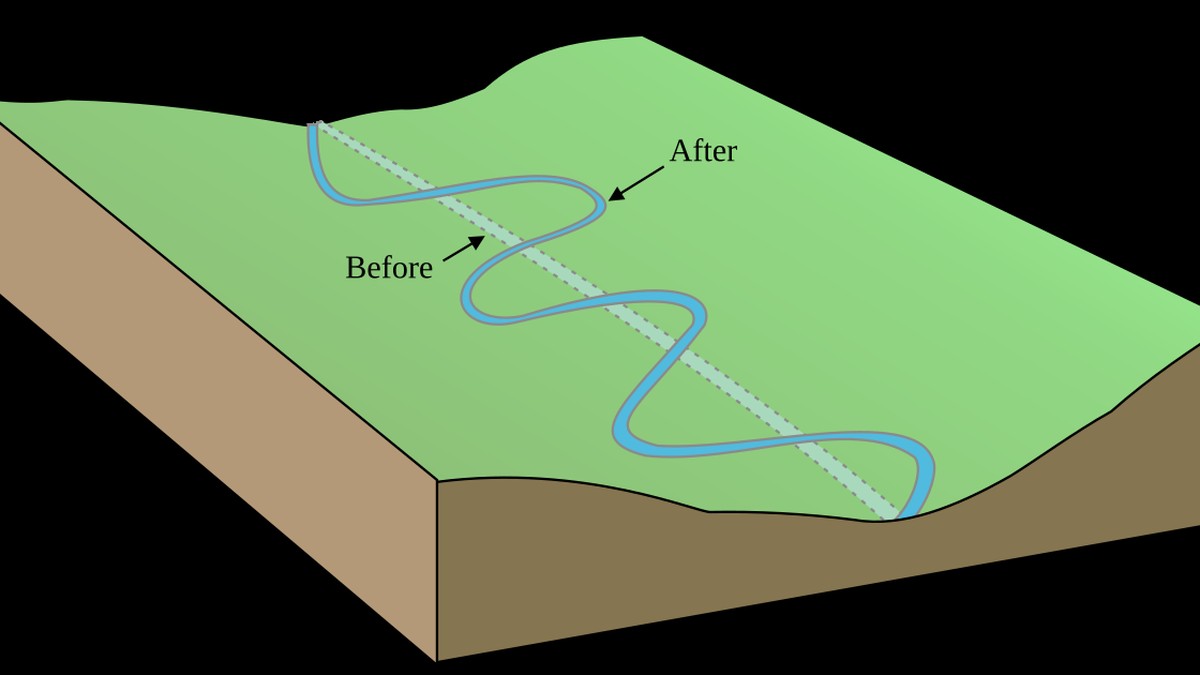
Meandering channels develop in physiographic settings characterized by moderate channel slopes, cohesive, fine-grained bank materials containing significant clay and silt fractions, and relatively consistent hydrographs. The initiation of meandering is driven by helical secondary circulation cells that operate orthogonal to the primary downstream flow direction. As flow rounds a river bend, centrifugal acceleration directs the high-velocity surface water toward the outer concave bank, inducing localized super-elevation of the water surface. This hydraulic head differential establishes a downward and inward return flow along the riverbed toward the inner convex bank, scouring the outer cut bank and depositing the mobilized sediment onto the inner bank to construct a point bar deposit.
Braided rivers, conversely, represent multi-threaded fluvial networks characterized by steep channel gradients, highly erodible and non-cohesive coarse bank sediments, and violent, rapidly fluctuating discharges. In braided streams, stream power exceeds the critical threshold required to maintain a single confined channel, causing mid-channel deposition of longitudinal and transverse gravel bars that repeatedly bisect the flow column. The morphology of braided channels is continuously unstable; during seasonal flood pulses, bars migrate rapidly, channels bifurcate and coalesce, and rapid bank collapse occurs as non-cohesive sand and gravel strata are undermined by basal scouring.
Anastomosing rivers represent an entirely distinct multi-channel regime: unlike braided networks, anastomosing channels consist of multiple, deep, stable, highly sinuous interconnected channels separated by cohesive, vegetated, semi-permanent floodplain islands formed under extremely low gradients and base-level aggradation regimes. Anastomosing systems are commonly found in rapidly subsiding tectonic basins, humid inland wetland depressions (such as the Okavango Delta in Botswana and the upper Columbia River wetlands in Canada), or coastal transition zones where downstream backwater hydraulic effects inhibit channel incision. Dense wetland vegetation stabilizes channel banks with root cohesion, while overbank splay deposition gradually aggrades inter-channel wetlands without destroying the multi-threaded network.
4. Meander Evolution, Cutoffs, and Oxbow Lake Formation
The evolutionary trajectory of an active meander loop represents a classical paradigm of morphological instability and self-limiting growth. As helical flow continuously excavates the outer concave bank through hydraulic plucking and basal undercutting, the meander loop expands laterally and elongates down-valley. The rate of lateral meander migration (M) is fundamentally controlled by the curvature ratio (r/w, where r represents the radius of curvature and w the channel width). Extensive hydrodynamic measurements indicate that meander migration rates peak when the r/w ratio is between 2.0 and 3.0; at tighter curvatures (r/w < 2.0), severe boundary flow separation along the inner bank introduces massive energy dissipation that dampens further lateral expansion.
Over decades to centuries of continuous lateral migration, adjacent meander loops expand toward one another until only an exceedingly narrow neck of land separates the upstream and downstream reaches. During catastrophic high-magnitude flood events, when the stage of the river overspills its bankfull confines, water surges across the meander neck along the path of steepest local hydraulic gradient. This concentrated overland flow incises a pilot channel that rapidly deepens via scour and headward knickpoint erosion, producing a chute cutoff or neck cutoff that captures the dominant discharge of the river.
Following meander abandonment, the entrance and exit limbs of the truncated loop experience immediate hydrological deceleration, causing rapid sedimentation of bedload and suspended sands at the junction points. These sedimentary plugs, known as sand plugs or silt dams, permanently seal the old river loop from the active river channel. The isolated, crescent-shaped channel remnant transitions into an oxbow lake (or billabong). In this lacustrine environment, current velocity drops to zero, and the oxbow gradually infills with fine organic matter, gyttja, and lacustrine silts, creating rich wetland ecosystems that serve as crucial biodiversity reservoirs within dynamic river floodplains.
Beyond individual meander cutoffs, entire alluvial reaches undergo catastrophic macro-scale reorganization through river avulsion. Avulsion occurs when an aggrading river channel builds its bed elevation above the surrounding floodplain through continuous sedimentation (a condition known as alluvial superelevation). During extreme floods, levee crevasses allow floodwaters to escape into low-lying floodplain backswamps, permanently carving an entirely new channel path that bypasses tens or hundreds of kilometers of the old riverbed. Avulsion is the primary mechanism driving delta lobe switching, as documented throughout the geological evolution of the Mississippi, Yellow (Huang He), and Rhine-Meuse deltas.
💧 Geomorphological Milestone: River Bifurcation & Avulsion
Avulsion represents the sudden, catastrophic relocation of a river’s entire course to a new location on its floodplain or deltaic plain. Driven by downstream channel aggradation, superelevation of the channel bed above the surrounding floodplain, and logjam blockages, avulsion creates new primary deltaic lobes, as documented historically in the Mississippi River delta complex and the Yellow River (Huang He) alluvial plain.
5. Floodplain Hydraulics, Terraces, and Longitudinal River Profiles
The interaction between the active river channel and its adjacent alluvial floodplain dictates the attenuation of catastrophic flood waves and the long-term sequestration of fine-grained sediment. When discharge exceeds the bankfull capacity—a statistical recurrence interval typically corresponding to the 1.5- to 2.3-year flood event on the annual maximum flood series—water spills over the channel crests, decelerating abruptly due to the friction of terrestrial vegetation. This sudden reduction in stream power prompts immediate deposition of coarser sands immediately adjacent to the bank, constructing elevated topographic ridges known as natural levees. Beyond the levees, tranquil overbank inundation deposits fine silts and clays across expansive flood basins and backswamps.
In response to long-term geological drivers such as tectonic uplift, isostatic rebound, climatic shifts, or base-level decline (such as marine regression during glacial epochs), rivers incise vertically into their pre-existing floodplains. When vertical incision outpaces lateral planform migration, the abandoned former floodplain is preserved as an elevated topographic bench termed an alluvial terrace. Terraces may be paired—occupying matching elevations on both flanks of the valley as a consequence of rapid, episodic downcutting—or unpaired, produced when lateral meandering accompanies continuous, slow incision across asymmetrical structural bedrock benches.
The overarching longitudinal profile of an undisturbed river network typically displays a concave-upward logarithmic curve, extending from steep, high-elevation headwater reaches to gentle, low-gradient coastal estuaries. This equilibrium profile represents the graded stream concept formalized by J. Hoover Mackin (1948), in which slope and cross-sectional geometry are adjusted to provide the precise velocity necessary to transport the sediment load supplied from the upstream drainage basin without ongoing aggradation or degradation. Departures from this ideal profile indicate tectonic fault scarps, lithological knickpoints, glacio-isostatic adjustments, or dam-induced hydrological disruptions.
Fluvial terraces also preserve rich paleoclimatic archives. By analyzing the stratigraphic architecture, grain-size distributions, pollen profiles, and cosmogenic radionuclide exposure ages (such as Beryllium-10 and Aluminum-26) of terrace deposits, geomorphologists reconstruct quaternary climatic shifts, identifying periods of intense periglacial sediment production versus post-glacial incision phases. Understanding these paleohydrological cycles is essential for predicting how modern anthropogenically accelerated climate change will alter sediment yields, flood recurrence intervals, and valley aggradation dynamics over the coming century.
6. Mathematical Modeling of Fluvial Systems: From 1D HEC-RAS to 3D Hydrodynamics
Contemporary fluvial geomorphology relies extensively on advanced numerical modeling suites to simulate flow fields, sediment routing, and channel morphological evolution. Classical one-dimensional hydraulic models, such as the U.S. Army Corps of Engineers’ HEC-RAS (Hydrologic Engineering Center’s River Analysis System), solve the 1D energy and Saint-Venant momentum equations across discrete cross-sections. While computationally efficient for regional flood inundation mapping and levee breach modeling, 1D models cannot capture cross-channel velocity gradients, secondary helical circulation, or asymmetrical shear stress distributions characteristic of natural meandering bends.
To overcome these limitations, two-dimensional depth-averaged models (e.g., Telemac-2D, Delft3D, and SRH-2D) solve the depth-integrated Reynolds-Averaged Navier-Stokes (RANS) equations, explicitly resolving lateral flow separation, recirculation eddies behind boulders and spur dikes, and shear-layer instabilities along floodplain-channel interfaces. In complex environments, such as turbulent plunge pools, dam spillway dissipation basins, and hyporheic interstitial flow fields, fully three-dimensional hydrodynamic models coupled with Large Eddy Simulation (LES) or Direct Numerical Simulation (DNS) frameworks resolve anisotropic turbulent vortices, providing unprecedented predictive fidelity for river restoration engineering and infrastructure risk mitigation.
These numerical hydraulic models are increasingly coupled with morphodynamic sediment transport modules that update the computational bed elevation mesh at every time step based on the Exner equation of sediment continuity (∂η/∂t = -[1/(1 – λ)] · ∇·qs, where η is bed elevation, λ is bed porosity, and qs is the volumetric sediment transport flux vector). By running long-term multi-decadal morphodynamic simulations, researchers assess how upstream dam decommissioning, gravel extraction moratoriums, or climate-induced precipitation deluges will reshape downstream river sinuosity, bridge scouring depths, and riparian wetland connectivity.
7. Synthesis and Global River Basin Conservation Horizons
The conservation and management of global river systems require a profound paradigm shift that moves beyond viewing rivers as isolated hydraulic conveyances toward treating them as integrated, living socio-ecological landscapes. The traditional approach of ‘taming’ rivers through continuous concrete revetments, levee walls, and deep-dredging channels has repeatedly triggered catastrophic unintended consequences: accelerated downstream flood crests, catastrophic land subsidence in sediment-starved deltas, and the catastrophic collapse of freshwater biodiversity, which is currently declining at more than twice the rate of terrestrial or marine species.
Process-based river restoration seeks to restore the dynamic physical processes that sustain natural channel heterogeneity. By implementing room-for-the-river initiatives—such as setting back earthen flood levees, re-meandering historically straightened drainage ditches, reactivating relict oxbow lakes, and augmenting sediment-starved reaches with gravel pulses—fluvial managers restore natural flood attenuation while reviving critical hyporheic and riparian ecosystems. In the face of intensifying global hydrological extremes, respecting the intrinsic geomorphological dynamics of rivers represents humanity’s most effective path toward long-term water security, flood resilience, and ecological sustainability.