1. Wetland Hydrology as the Primary Ecological Driver
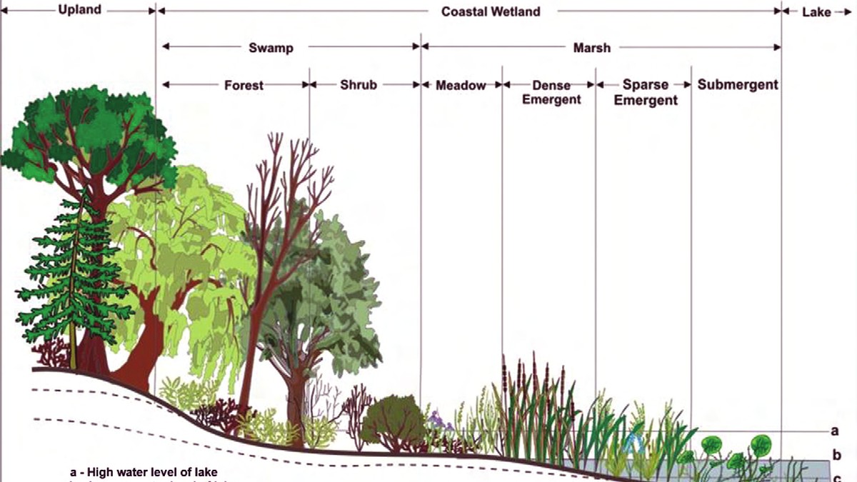
Wetlands occupy the dynamic ecotone between purely terrestrial and permanently aquatic ecosystems. Far from being marginal wastelands, wetlands are among the most biologically productive, biogeochemically active, and hydrologically indispensable landscapes on planet Earth. The singular, non-negotiable master variable dictating the genesis, physical structure, and ecological persistence of every wetland is its hydrologic regime—the spatial and temporal pattern of water depth, duration, frequency, and seasonality of inundation, formally designated as the wetland’s hydroperiod.
The hydroperiod acts as an uncompromising evolutionary filter. When soil becomes saturated with water, molecular diffusion of dissolved oxygen through water-filled pore spaces is approximately 10,000 times slower than through air. Within hours or days, aerobic microbial respiration completely consumes the residual dissolved oxygen, driving the soil into severe anoxia and reducing the redox potential (Eh) from +500 mV down to -300 mV. This profound biogeochemical transformation creates hydric soils characterized by diagnostic redoximorphic features: mottled gleying (Fe²⁺ reduction creating steel-gray colors), oxidized rhizospheres along live roots, and thick accumulations of un-decomposed organic matter (peat and muck).
Flora colonizing wetlands must possess specialized physiological and anatomical adaptations—termed hydrophytic adaptations—to thrive in waterlogged, anoxic substrates. These adaptations include aerenchyma tissue (porous spongy internal tissue with large gas-filled intercellular spaces that conduits oxygen from aerial foliage downward into submerged roots), adventitious root production, hypertrophied lenticels on woody trunks, and specialized metabolic pathways capable of enduring anaerobic fermentation without lethal ethanol accumulation (e.g., in bald cypress, Taxodium distichum, and cattails, Typha latifolia).
From a landscape geomorphic perspective, the Cowardin and hydrogeomorphic (HGM) classification systems categorize wetlands by geomorphic position, dominant water source, and hydrodynamics. Riverine wetlands flank active stream corridors and receive pulsed overbank flows; depressional wetlands (such as vernal pools and prairie potholes) collect diffuse surface runoff and groundwater in topographic hollows; and slope wetlands (fens and seeps) develop where groundwater exfiltrates along break-in-slope hillsides. Each hydrogeomorphic class exhibits distinct hydraulic retention times, modulating how effectively the wetland can physically capture suspended clastic sediment and biologically process dissolved agricultural contaminants.
The water budget of a wetland is mathematically expressed as: ΔV = P_net + S_in + G_in – ET – S_out – G_out ± T, where P_net is net precipitation (accounting for canopy interception), S_in and S_out represent surface inflow and outflow, G_in and G_out denote groundwater discharge and recharge, ET is actual evapotranspiration, and T represents tidal flux in coastal systems. Subtle shifts in any single term can alter the hydroperiod, transforming a seasonal vernal pool into an open-water marsh or causing the complete terrestrialization of a forested peatland.
💧 Wetland Ecology Law: The Hydroperiod Dictates Everything
Hydrology is the sovereign architect of wetlands. It dictates soil biogeochemistry, which in turn determines nutrient availability, which ultimately selects the hydrophytic plant community. Altering water levels by as little as 5 to 10 centimeters can completely destroy wetland ecological functioning.
2. Biogeochemical Nutrient Sinks: Denitrification and Phosphorus Sequestration
Wetlands are universally celebrated as the ‘kidneys of the landscape’ due to their peerless capacity to filter, transform, and permanently sequester dissolved chemical pollutants and agricultural nutrients. In intensive agricultural and urbanized watersheds, wetlands operate as critical natural biogeochemical bioreactors that intercept diffuse non-point source nutrient loads before they reach river networks and coastal seas.
The most vital chemical service performed by wetlands is biological denitrification. Agricultural runoff carries astronomical concentrations of dissolved nitrate (NO3⁻) originating from synthetic nitrogen fertilizers. Within the saturated, anoxic wetland soil profile, facultative anaerobic heterotrophic bacteria (such as Pseudomonas, Paracoccus, and Alcaligenes) utilize nitrate as their terminal electron acceptor for respiration in the absence of molecular oxygen:
2 NO3⁻ + 10 e⁻ + 12 H⁺ → N2(g) + 6 H2O
This biochemical cascade reduces toxic nitrate successively to nitrite (NO2⁻), nitric oxide (NO), nitrous oxide (N2O), and ultimately to inert dinitrogen gas (N2), which harmlessly vents into the atmosphere. Because the atmosphere consists of 78% N2 gas, this process permanently eliminates the excess reactive nitrogen from the aquatic biosphere. Denitrification rates in warm, carbon-rich wetland soils are extraordinary, regularly eliminating 50% to 90% of total influent nitrate loads within hydraulic residence times of only 2 to 5 days.
Phosphorus removal in wetlands operates through an entirely different suite of mechanisms because phosphorus lacks an atmospheric gas phase. Phosphorus is retained through three primary pathways: plant uptake during the active growing season (a seasonal, reversible sink), chemical adsorption onto clay mineral lattices and amorphous aluminum/iron oxides, and, most importantly, long-term accretion of refractory organic matter (peat). In undisturbed peatlands and cypress swamps, recalcitrant plant roots and lignin residues resist microbial decay under permanent anoxia, burying phosphorus securely in the sub-surface geological record for centuries.
| Nutrient Pollutant | Primary Removal Mechanism | Biogeochemical Pathway | Removal Efficiency (%) | Permanence of Storage |
|---|---|---|---|---|
| Nitrate (NO3⁻) | Microbial Denitrification | Anoxic heterotrophic reduction to inert N2 gas | 60 – 95% | Permanent (Vented to atmosphere) |
| Ammonium (NH4⁺) | Coupled Nitrification-Denitrification | Aerobic oxidation to NO3⁻, then anoxic reduction | 40 – 80% | Permanent (Atmospheric venting) |
| Orthophosphate (PO4³⁻) | Peat Accretion & Mineral Adsorption | Binding to Fe/Al oxides & burial in un-decomposed peat | 30 – 75% | Long-term (Subject to redox release) |
| Suspended Particulates | Physical Gravitational Sedimentation | Velocity reduction in dense emergent vegetation | 80 – 98% | Semi-permanent (Benthic burial) |
| Pesticides / Herbicides | Microbial Degradation & Bio-sorption | Anaerobic co-metabolism and humic binding | 50 – 85% | Moderate to permanent transformation |
3. Riparian Buffer Strips: Three-Zone Architecture and Filtration Mechanics
Riparian zones—the linear terrestrial corridors flanking river channels—function as the frontline ecological shield protecting riverine ecosystems from catchment land-use impacts. When designed and preserved with multi-tiered vegetative structure, riparian buffer strips perform phenomenal hydrological, thermal, and geomorphic buffering functions.
Modern ecological engineering prescribes the standardized Three-Zone Riparian Buffer Model (Welsch, 1991) to maximize ecosystem services across agricultural landscapes:
- Zone 1 (Streamside Undisturbed Forest): Extending a minimum of 5 to 10 meters directly from the top of the stream bank. Consisting of mature, native hardwood trees and wetland shrubs, Zone 1 is a strictly unmanaged sanctuary. Its massive root networks physically bind stream bank sediments, halting shear bank erosion. Mature tree canopies cast dense thermal shade across the water column, preventing lethal summer water temperature spikes and suppressing filamentary algae blooms. Furthermore, Zone 1 continuously sheds large woody debris (LWD) into the channel, creating structural habitat complexity and plunge pools essential for salmonid fishes.
- Zone 2 (Managed Transition Forest): Extending 15 to 30 meters upslope from Zone 1. Comprising fast-growing hardwoods, conifers, and understory shrubs, Zone 2 provides an active biogeochemical processing zone. Deep tree root networks intercept shallow groundwater flowing toward the stream, extracting dissolved nitrates and agrochemicals through root absorption and stimulating active rhizosphere microbial denitrification.
- Zone 3 (Runoff Grass Filter Strip): Extending 5 to 10 meters upslope from Zone 2, adjacent to cultivated crop fields or pastures. Comprising dense, stiff-stemmed native bunchgrasses (e.g., switchgrass, Panicum virgatum), Zone 3 converts concentrated agricultural sheet flow into dispersed shallow flow, filtering out 80% to 90% of coarse suspended sediment and particulate-bound phosphorus via physical frictional trapping before runoff enters the forest.
Riparian corridors also serve as critical ecological highways—continuous, unbroken wildlife corridors that facilitate genetic flow, migratory movements, and climate-tracking dispersal for terrestrial mammals, birds, amphibians, and insects across otherwise fragmented agricultural and urbanized landscapes.
Thermal Microclimate Regulation by Riparian Canopies
Stream water temperature is governed by solar radiation flux: Q_solar = I_0 · (1 – Shade). In unshaded, clear-cut agricultural streams, incident solar radiation can heat shallow headwater channels by 6°C to 12°C during summer afternoons. Intact riparian canopies intercept up to 85% to 95% of incoming solar irradiance, maintaining coldwater thermal regimes (< 18°C) essential for the survival of temperature-sensitive salmonids, trout, and rheophilic macroinvertebrates.
💧 Riparian Design Rule: The 30-Meter Buffer Benchmark
Meta-analyses across hundreds of global catchments confirm that a multi-species riparian buffer strip measuring at least 30 meters (100 feet) in width consistently removes over 85% of suspended sediments, 80% of dissolved nitrate, and stabilizes 90% of stream bank integrity against bankfull shear stress.
4. Floodplain Inundation Dynamics and Hydrograph Attenuation
Natural floodplains are dynamic hydrological safety valves. A floodplain is a broad, low-relief alluvial landform bordering a river channel, constructed over millenary timescales by lateral channel migration and vertical overbank sediment accretion. During low and moderate flows, water is confined entirely within the channel banks; however, during high-magnitude flood events exceeding the 1.5- to 2.0-year recurrence interval (bankfull stage), the river breaches its banks, inundating the vast expanse of the floodplain.
The hydrological value of this overbank connection is the dramatic attenuation of the flood hydrograph. When a flood wave surges through an artificial concrete canal or a channelized, leveed river, water is laterally constricted. Because the cross-sectional hydraulic radius is high and boundary roughness is low, the flood wave travels downstream at high velocities, arriving downstream as a steep, towering, catastrophic discharge spike.
Conversely, when a flood wave breaches its banks onto a connected, forested floodplain, two profound physical changes occur:
- Monumental Surface Storage Capacity: The lateral spreading of water converts vast square kilometers of floodplain into temporary shallow lakes, storing millions of cubic meters of water that would otherwise surge downstream.
- Hydraulic Roughness and Friction: Dense floodplain vegetation—mature tree trunks, fallen logs, tangled understory brush, and wetland hummocks—exerts immense hydrodynamic frictional drag, drastically increasing Manning’s roughness coefficient (n jumps from ~0.035 in the channel to 0.100–0.160 on the forested floodplain). This frictional drag decelerates flow velocity from several meters per second down to less than 0.3 m/s.
The mathematical result is hydrograph de-synchronization and peak shaving: the sharp, dangerous flood crest is flattened into a low, prolonged discharge plateau, reducing downstream peak water stages by meters and delaying the flood crest by hours or days, providing invaluable evacuation and mitigation time for downstream metropolitan centers.
5. Channelization, Levee Confinement, and Wetland Drainage Degradation
Over the past two centuries, anthropogenic engineering has systematically dismantled natural wetland and floodplain hydrological functioning across the globe. Driven by agricultural land reclamation and flood control doctrines, societies constructed thousands of kilometers of artificial earthen levees, armored floodwalls, and straightened natural meandering river channels into linear drainage canals.
In the contiguous United States, over 53% of all natural wetlands have been drained and destroyed since European colonization, with losses exceeding 90% in intensive agricultural states such as Iowa, Illinois, and California’s Central Valley. Across Europe, over two-thirds of natural floodplains are severed from their rivers by continuous levee networks. This systematic disconnection has triggered catastrophic hydrological feedback loops.
Severing a river from its floodplain concentrates the entire flood energy within a narrow artificial corridor, accelerating downstream flood velocities and causing catastrophic levee breaches downstream (the ‘levee effect’). Furthermore, channel bed incision accelerates: trapped within high levees, high-velocity flood flows scour the riverbed downward, dropping the stream bed elevation by meters. This incised channel acts as a giant French drain, lowering the surrounding regional water table, desiccating adjacent floodplain wetlands, and transforming lush riparian ecosystems into dry, invasive-dominated weed plains.
Additionally, the loss of wetland denitrification capacity has unleashed massive nutrient export into global oceans. Agricultural nitrogen and phosphorus discharging unattenuated down the channelized Mississippi-Atchafalaya River Basin fuel a colossal summer hypoxic ‘dead zone’ in the northern Gulf of Mexico covering over 15,000 to 22,000 square kilometers, annihilating benthic marine life and crippling commercial fisheries.
6. Modern Ecological Restoration: Levee Setbacks and Re-Meandering
To reverse these continental-scale environmental catastrophes, modern river basin management is embracing Process-Based River and Floodplain Restoration. Rather than continuing to invest billions in maintaining failing concrete hard-engineering structures, environmental agencies are prioritizing nature-based solutions that reconnect rivers with their natural floodplains.
Premier among these modern techniques is the implementation of levee setbacks. Instead of building levees directly on the river’s active banks, setback levees are constructed hundreds of meters or kilometers inland. This intervention restores floodwater access to thousands of acres of historical floodplain, expanding flood storage capacity, reducing peak flood stages, and revitalizing native wetland and riparian habitats without compromising the flood safety of upland agricultural communities or infrastructure.
Simultaneously, hydrologists are executing extensive stream re-meandering and dam removal projects. Re-introducing sinuous meander curves, re-connecting abandoned oxbow lakes, and installing engineered log jams (ELJs) restores natural pool-riffle sequences, elevates incised stream beds, and reconnects groundwater tables. Furthermore, beaver re-introduction programs (Castor canadensis and Castor fiber) are increasingly deployed as low-cost, self-maintaining ecological engineers whose natural dams create complex wetland mosaics that store water, trap sediment, and buffer watersheds against catastrophic wildfires.
By restoring wetlands, riparian buffers, and dynamic floodplains to our drainage basins, society restores the natural ecological defenses of our landscapes, ensuring clean water, abundant biodiversity, and robust flood resilience in a warming world.