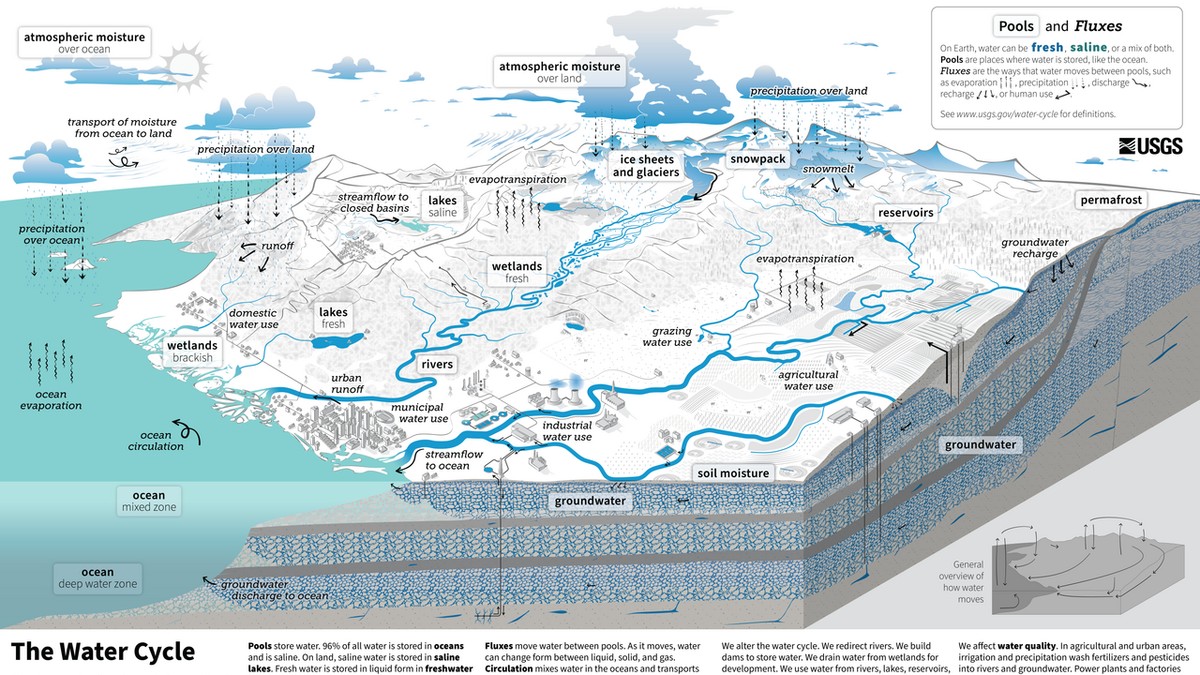
1. Planetary Thermomechanics of the Global Water Cycle
The global hydrological cycle represents the most immense physical mass-transport and thermodynamic energy-distribution engine operating within the Earth system. Driven ceaselessly by incident solar irradiance and modulated by planetary gravitation, the cycle continuously circulates water through its vapor, liquid, and solid phases across the atmosphere, oceans, terrestrial biosphere, and cryosphere. Far from being a mere passive transport of moisture, the water cycle operates as the primary thermodynamic regulator of Earth’s climate, responsible for redistributing over 50% of the planetary meridional heat flux from the solar-surplus equatorial tropics toward the energy-deficit polar latitudes through the latent heat of phase transitions.
The total global water inventory of planet Earth is estimated at approximately 1,386 million cubic kilometers (km³). However, liquid freshwater accessible for terrestrial biological life represents an infinitesimally small fraction of this planetary total. The World Ocean contains 96.5% (~1,338 million km³) of all global water in saline form. The cryosphere—encompassing polar ice sheets, ice caps, and alpine glaciers—locks away approximately 1.74% (~24 million km³), accounting for roughly 68.7% of all global freshwater. Groundwater aquifers hold an additional 1.69% (~23.4 million km³, representing 30.1% of global freshwater). In stark contrast, all the world’s freshwater lakes, rivers, atmospheric moisture, and biological biomass combined account for a mere 0.07% of the total hydrosphere.
Atmospheric water vapor, despite its minuscule volume of approximately 12,900 cubic kilometers (equivalent to an average global liquid depth of only 25 millimeters if condensed uniformly over the Earth’s surface), exhibits extraordinary thermodynamic and transport velocity. The mean residence time of a water molecule in the global atmosphere is remarkably brief—averaging only 8.2 to 9.5 days. This rapid atmospheric turnover means that the planetary atmosphere refills and completely empties its total moisture inventory roughly 40 times per year, driving a relentless global precipitation-evaporation flux of approximately 502,800 cubic kilometers annually.
The quantitative balance of the global cycle reveals profound terrestrial-oceanic asymmetries. Over the global oceans, evaporation (approx. 436,500 km³/year) significantly exceeds marine precipitation (approx. 398,500 km³/year), generating a net oceanic moisture deficit of roughly 38,000 km³/year. This excess evaporated moisture is transported across continental margins by atmospheric wind fields as advective vapor flux. Over terrestrial landmasses, precipitation (approx. 111,000 km³/year) substantially exceeds terrestrial evapotranspiration (approx. 73,000 km³/year). The resulting terrestrial surplus of roughly 38,000 to 40,000 km³/year returns inexorably to the global oceans via river discharge and direct subterranean groundwater baseflow, perfectly closing the planetary mass conservation loop.
💧 Thermodynamic Milestone: Latent Heat as Climate Engine
Every kilogram of water evaporated from tropical oceans absorbs approximately 2.45 Megajoules (MJ) of latent heat of vaporization. When this moisture condenses into convective storm clouds in mid-latitudes, that stored energy is released into the upper troposphere, driving global atmospheric jet streams and cyclone dynamics.
2. Atmospheric Rivers and Planetary Moisture Conveyor Belts
For decades, classical meteorology conceptualized atmospheric moisture transport as broad, diffuse hemispheric vapor drift. However, modern satellite microwave radiometry, dropsondes, and Lagrangian moisture tracking models have revealed that the vast majority of meridional vapor transport is concentrated into narrow, intense, filamentary conduits known as Atmospheric Rivers (ARs).
An atmospheric river is defined as a long, narrow transient corridor of intense horizontal water vapor transport, typically spanning thousands of kilometers in length while measuring only 400 to 600 kilometers in width. Despite covering less than 10% of the Earth’s zonal circumference at any given time, atmospheric rivers account for over 90% of all poleward atmospheric water vapor transport across mid-latitudes. The instantaneous moisture flux carried by a major atmospheric river—such as the iconic ‘Pineapple Express’ originating in the tropical Pacific near Hawaii—routinely exceeds 10 to 20 million kilograms of water vapor per second, a flux equivalent to 7 to 15 times the average volumetric liquid discharge of the Mississippi River mouth.
The synoptic structure of an atmospheric river is anchored within the warm conveyor belt of extratropical maritime cyclones. Fueled by low-level jet streams operating at altitudes of 1 to 2.5 kilometers (within the 850–700 hPa atmospheric pressure stratum), strong winds convey saturated tropical air poleward ahead of advancing cold fronts. Integrated Vapor Transport (IVT), mathematically defined as the vertical integral of horizontal wind velocity multiplied by specific humidity from the surface to the 300 hPa level (IVT = 1/g · integral[q · V · dp]), serves as the standard metric for categorizing AR intensity on the Ralph et al. (2019) Scale from Category 1 (primarily beneficial) to Category 5 (primarily hazardous and catastrophic).
When these airborne moisture conveyor belts strike elevated coastal mountain ranges—such as the Sierra Nevada and Cascades in North America, the Southern Alps in New Zealand, or the Patagonian Andes—forced orographic lifting triggers rapid condensation. The resulting torrential precipitation can deposit 20% to 50% of a region’s entire annual rainfall or snowpack in a single 48-hour storm event, simultaneously supplying vital water reservoirs while posing catastrophic flood and debris flow hazards.
| Hydrospheric Reservoir | Volume (km³) | Percent of Total Water (%) | Percent of Freshwater (%) | Mean Residence Time |
|---|---|---|---|---|
| World Ocean | 1,338,000,000 km³ | 96.54% | — (Saline) | 2,500 – 3,200 Years |
| Glaciers & Ice Sheets (Cryosphere) | 24,064,000 km³ | 1.74% | 68.7% | 100 – 10,000 Years |
| Groundwater (Saturated Zone) | 23,400,000 km³ | 1.69% | 30.1% | 2 weeks (shallow) to 10,000 years (deep) |
| Freshwater Lakes | 91,000 km³ | 0.007% | 0.26% | 1 – 100 Years |
| Soil Moisture (Vadose Zone) | 16,500 km³ | 0.001% | 0.05% | 1 – 2 Months |
| Atmosphere (Vapor & Clouds) | 12,900 km³ | 0.001% | 0.04% | 8.2 – 9.5 Days |
| River Networks | 2,120 km³ | 0.0002% | 0.006% | 12 – 20 Days |
| Biological Biomass | 1,120 km³ | 0.0001% | 0.003% | ~1 Week |
3. Terrestrial Water Budgets and Continental Runoff Generation
The partitioning of precipitation at the continental surface governs terrestrial ecosystem survival, river basin yields, and water resources availability. The terrestrial water budget over a river basin or continent is formalized as: P = ET + Q + ΔS_soil + ΔS_gw + ΔS_snow, where P is precipitation, ET is actual evapotranspiration, Q is total runoff, and the ΔS terms represent storage changes in soil moisture, deep groundwater aquifers, and snow/ice reservoirs.
Globally, approximately 65% of all meteoric precipitation falling on terrestrial continents returns directly to the atmosphere via evapotranspiration (green water flux), while the remaining 35% enters stream networks, lakes, and extractable aquifers as liquid streamflow (blue water flux). This partitioning ratio varies radically across biomes: in arid deserts and semi-arid shrublands, evapotranspiration frequently consumes 90% to 98% of total precipitation, leaving negligible runoff; in humid temperate rainforests and high-altitude alpine zones, runoff fractions can exceed 60% to 75%.
Runoff generation operates through two primary physical paradigms:
- Infiltration-Excess (Hortonian) Overland Flow: Occurs when rainfall intensity exceeds the infiltration capacity of the soil, independent of moisture storage depth. Dominant in arid regions, disturbed agricultural soils, and impervious urban landscapes.
- Saturation-Excess (Dunne) Overland Flow: Occurs when prolonged precipitation or high groundwater tables saturate the entire soil column from below to the surface. Any subsequent rainfall, regardless of intensity, cannot infiltrate and immediately runs off. Dunne overland flow is the dominant mechanism in humid, vegetated, temperate catchments, originating predominantly from expanding and contracting variable source areas in valley bottoms and near-stream riparian zones.
The continuous interaction between surface water and groundwater maintains the baseflow of continental rivers during extended dry seasons. In undisturbed catchments, up to 70% of total annual stream discharge is delivered via subterranean groundwater pathways, demonstrating that rivers are merely the visible, exfiltrating manifestation of vast, hidden subterranean hydrogeological circuits.
Variable Source Area (VSA) Hydrology
Pioneered by John Hewlett and Craig Hibbert (1967), VSA hydrology shattered the assumption that runoff is generated uniformly across a watershed. In reality, overland flow is restricted to dynamic saturated source zones flanking stream channels that expand during wet winter seasons and contract during dry summer months, accounting for as little as 5% to 15% of total basin area while generating over 90% of storm runoff.
💧 Hydrological Paradigm: Blue vs. Green Water
Modern water resources science distinguishes between ‘Green Water’ (soil moisture consumed by terrestrial ecosystems and returned via transpiration) and ‘Blue Water’ (liquid runoff in rivers, lakes, and aquifers available for human extraction). Global food production is 80% reliant on green water.
4. Ocean-Atmosphere Feedbacks and Teleconnections (ENSO, IOD)
The global hydrological cycle is coupled to oceanic thermal oscillations that modulate atmospheric moisture pathways across planetary scales. Foremost among these coupled ocean-atmosphere phenomena is the El Niño-Southern Oscillation (ENSO), operating in the equatorial Pacific Ocean with a pseudo-cyclical periodicity of 2 to 7 years.
Under neutral conditions, easterly Pacific trade winds blow warm equatorial surface waters westward, pooling warm water in the Indo-Pacific Warm Pool and driving intense convective precipitation over Southeast Asia and northern Australia, while cold, nutrient-rich deep waters upwell along the South American coast (Walker Circulation). During an El Niño event, trade winds weaken or reverse; the warm surface water pool surges eastward across the Pacific toward South America, shifting the core of tropical convective precipitation thousands of miles eastward.
This eastward convective displacement triggers planetary-scale atmospheric Rossby waves that disrupt weather patterns globally—a phenomenon termed teleconnections. El Niño typically induces catastrophic droughts across eastern Australia, Indonesia, and southern Africa, while unleashing torrential rainfall, atmospheric river landfalls, and severe flooding along the western coasts of South America and California. Conversely, during a La Niña phase, intensified trade winds amplify normal conditions, causing catastrophic monsoon flooding in Australia and Bangladesh while locking southwestern North America into multi-year megadroughts.
Similarly, the Indian Ocean Dipole (IOD) modulates hydrological cycles across Africa and Asia. A positive IOD phase—characterized by anomalously warm sea surface temperatures in the western Indian Ocean and cold upwelling off Sumatra—drives torrential rains and flooding in East Africa while starving Australia and Indonesia of seasonal monsoonal moisture, exacerbating catastrophic wildfire firestorms.
5. Deep Subsurface and Lithospheric Water Cycling
While hydrological science typically focuses on the surficial atmosphere-ocean-terrestrial cycle, a vast, slow-moving ‘deep water cycle’ operates within the interior mantle and crust of the Earth over geological timescales of hundreds of millions of years. Hydrated oceanic lithosphere—rich in serpentinite and hydrous clay minerals formed through hydrothermal seawater circulation at mid-ocean ridges—is carried into the deep mantle via subduction zones.
As the subducting oceanic plate plunges into the asthenosphere under escalating temperature and pressure, hydrous minerals undergo metamorphic dehydration reactions, releasing supercritical aqueous fluids into the overlying mantle wedge. This fluid flux lowers the melting point of the mantle peridotite (flux melting), generating basaltic arc magmatism that powers explosive island arc volcanism (e.g., the Pacific ‘Ring of Fire’). Volcanic outgassing subsequently vents juvenile and recycled water vapor back into the surface atmosphere via fumaroles and explosive eruptions.
High-pressure mineral physics investigations reveal that the Earth’s mantle transition zone (located between 410 and 660 kilometers depth) contains minerals—specifically wadsleyite and ringwoodite (high-pressure polymorphs of olivine)—capable of storing up to 1.5% to 2.5% of their total crystal weight as hydroxyl (OH⁻) ions within their mineral lattices. The total volume of water chemically locked within the Earth’s mantle transition zone is estimated to be equal to or greater than the entire volume of all the world’s surface oceans combined (1.5 to 3 ocean equivalents).
This profound lithospheric reservoir proves that the surface hydrosphere is not a closed container; it is in continuous, dynamic, long-term equilibrium with the subterranean interior of the planet, regulating global sea levels and continental freeboard across billions of years of planetary evolution.
6. Anthropogenic Intensification of the Hydrological Cycle in the 21st Century
Human carbon emissions and planetary warming are accelerating and destabilizing the global hydrological cycle at a velocity unprecedented in the Holocene epoch. The thermodynamic foundation governing cycle intensification is the Clausius-Clapeyron relation, which dictates that the water-vapor holding capacity of the atmosphere increases exponentially by approximately 7% for every 1°C increase in tropospheric temperature: e_s(T) ≈ 0.611 · exp([17.27 · T] / [T + 237.3]).
As the global atmosphere warms, its capacity to hold moisture expands dramatically. This thermodynamic reality drives a planetary hydrological paradox: the wet get wetter, and the dry get drier. In arid and semi-arid continental interiors, elevated atmospheric vapor pressure deficits (VPD) accelerate terrestrial evapotranspiration, desiccating soils, intensifying agricultural flash droughts, and curing forest fuels for unprecedented wildfire mega-conflagrations. Conversely, when atmospheric instability triggers precipitation, storm clouds hold substantially greater precipitable water columns, unleashing hyper-intense cloudbursts, extreme convective rainfall, and catastrophic flash flooding.
Satellite gravimetry observations from the GRACE (Gravity Recovery and Climate Experiment) mission document widespread depletion of continental freshwater storage across major global breadbaskets—including the North China Plain, Northwest India, the Middle East, and the Central Valley of California. This depletion is driven by the deadly combination of diminished mountain snowpack meltwater and unsustainable, predatory over-pumping of fossil groundwater aquifers to sustain irrigated agriculture.
Confronting this global freshwater crisis requires a paradigm shift toward planetary hydrological stewardship: treating groundwater, atmospheric rivers, forests, and wetlands as a singular, indivisible thermodynamic system. Preserving planetary water stability requires rapid decarbonization to stabilize the tropospheric energy balance, coupled with aggressive watershed-scale ecological restoration, managed aquifer recharge, and regenerative agro-ecology that rebuilds the water-holding capacity of continental soils.