1. Cryospheric Geomorphology and Glacial Basin Genesis
Glacial erosion and deposition constitute the single most prolific geomorphic agent responsible for the creation of freshwater lakes on modern Earth. Over 70% of the world’s natural lakes by count—encompassing the vast lake districts of northern North America, Scandinavia, the Scottish Highlands, and Patagonia—were carved or impounded by the advance and retreat of massive Pleistocene ice sheets and alpine glaciers during the Last Glacial Maximum (LGM) approximately 20,000 years ago.
Glacial basin genesis operates through two primary mechanical processes: glacial quarrying (plucking) and glacial abrasion. As immense continental ice masses, often kilometers thick, flow under gravitational force, subglacial meltwater infiltrates fractures in the underlying bedrock. Diurnal and seasonal freeze-thaw cycles freeze this water, shattering rock masses through frost wedging. The advancing ice subsequently plucks loosened bedrock blocks and incorporates them into the basal debris layer. Concurrently, clastic debris dragged along the glacier bed acts as a monumental rasp, striating, polishing, and gouging rock hollows to produce over-deepened rock basins that fill with meltwater upon glacial retreat.
In mountainous alpine terrain, rotational glacial sliding carves steep-walled, bowl-shaped amphitheatres known as cirques (or corries). When the cirque glacier melts, meltwater collects within the over-deepened rock basin, held back by a bedrock lip or moraine sill to form a pristine alpine tarn. Where valley glaciers descend pre-existing fluvial valleys, differential rock hardness and convergent ice flow carve elongated, over-deepened troughs that evolve into deep paternoster lakes (chains of stepped rock basins connected by cascading streams) and monumental fjord lakes (such as Lake Chelan in Washington, Lake Wakatipu in New Zealand, and the fjord-like fingers of the Norwegian interior).
On continental scales, the Laurentide and Fennoscandian ice sheets exploited structural bedrock weaknesses, tectonic fault zones, and pre-glacial river valleys to scoop out the planet’s largest glacial depressions. The North American Great Lakes (Superior, Michigan, Huron, Erie, and Ontario) and the great subarctic lakes of Canada (Great Bear Lake, Great Slave Lake, Lake Athabasca, and Lake Winnipeg) represent massive proglacial scours where continental ice lobing over-deepened soft Paleozoic sedimentary strata against resistant crystalline Precambrian Canadian Shield rocks.
💧 Cryospheric Mechanism: Glacial Over-Deepening
Glacial valleys frequently exhibit reverse bed slopes where the bedrock floor drops significantly below sea level before rising again at a terminal rock threshold. Lake Superior’s floor plunges to 406 meters below the lake surface (223 meters below sea level), carved entirely by the compressive flow and plucking mechanics of the Superior Lobe of the Laurentide Ice Sheet.
2. Kettle Lakes and Fluvioglacial Dead-Ice Topography
Across glacial outwash plains (sandurs) and morainic landscapes, a distinct, highly ubiquitous category of small water bodies arises through the burial and delayed melting of stagnant ice blocks: the kettle lake (or pothole lake). As Pleistocene ice sheets suffered terminal climatic collapse, retreating ice margins fractured into isolated masses of stagnant ‘dead ice’ that were no longer nourished by active upstream ice flow.
Surging braided meltwater streams issuing from the decaying glacier carried monumental volumes of coarse glaciofluvial outwash—gravels, sands, and silts—which engulfed and completely buried these stagnant ice blocks under meters or tens of meters of sediment. Because thick sedimentary blankets provide excellent thermal insulation against summer solar radiation, these buried ice masses frequently persisted for centuries, and in some permafrost zones for millennia, after the active glacier had retreated hundreds of kilometers to the north.
Eventually, progressive geothermal heat flux and regional warming penetrated the insulating overburden, causing the buried ice block to melt slowly. As the supporting ice core liquidated, the overlying gravels and sands underwent catastrophic gravitational collapse, slumping downward into the newly created void to produce a steep-sided, circular to irregular topographic depression known as a kettle hole. Where the floor of this kettle hole penetrates beneath the local regional water table, it permanently fills with groundwater and precipitation, creating a kettle lake.
Kettle lakes are characteristically steep-sided, funnel-shaped, and often lack surface inflows or outflows, functioning as hydrologically closed seepage lakes. In North America’s Prairie Pothole Region—extending across the northern Great Plains of Canada and the United States—millions of kettle depressions form one of the world’s most critical wetland complexes, serving as the primary breeding grounds for over 50% of North America’s migratory waterfowl.
| Lake Classification | Primary Genesis Mechanism | Key Geomorphic Diagnostic | Hydrological Connection | Representative Examples |
|---|---|---|---|---|
| Cirque Tarn | Rotational subglacial plucking & quarrying | Steep-walled cirque amphitheatre; bedrock lip | Surface alpine stream drainage; meltwater-fed | Lake Tear of the Clouds (NY), Cadair Idris (Wales) |
| Kettle / Pothole Lake | Burial and delayed melting of dead ice blocks | Steep conical depressions; pitted outwash plains | Groundwater seepage-dominated; rarely surface outlets | Walden Pond (MA), Prairie Potholes (ND, SK) |
| Moraine-Dammed Lake | Terminal or lateral moraine impoundment | Unconsolidated clastic ridge dams; prone to GLOFs | Open fluvial through-flow; high sediment inputs | Lake Como (Italy), Moraine Lake (Canada), Imja Tsho (Nepal) |
| Volcanic Caldera Lake | Catastrophic collapse of emptied magma chamber | Steep circular caldera walls; ultra-deep; pristine | Closed hydrological caldera; precipitation-fed | Crater Lake (OR), Lake Toba (Indonesia), Lake Taupo (NZ) |
3. Moraine-Dammed Basins and Glacial Lake Outburst Floods (GLOFs)
Where retreating glaciers leave behind massive ridges of poorly sorted glacial debris—terminal, recessional, or lateral moraines—these ridges frequently act as natural dams, impounding meltwater behind them to form moraine-dammed lakes. In high-altitude mountain ranges, including the Himalayas, Andes, Alps, and Southern Alps of New Zealand, rapid modern glacier retreat has accelerated the formation and explosive volumetric expansion of hundreds of dangerous proglacial moraine-dammed lakes.
Unlike engineered concrete dams or solid bedrock sills, moraine dams are inherently unstable geomorphic structures. They consist of loose, unstratified, heterogeneous mixtures of clay, silt, sand, cobbles, and massive boulders (till) held together merely by gravity and internal friction. In many high-alpine environments, the core of the moraine dam contains relict buried glacial ice (ice-cored moraines). As global temperatures warm, this internal ice core melts, generating internal voids, piping cavities, and geotechnical shear failure within the moraine structure.
The catastrophic failure of a moraine dam triggers a Glacial Lake Outburst Flood (GLOF)—an extreme hydrological hazard capable of discharging tens of millions of cubic meters of water within a few hours, generating peak discharge hydrographs that exceed standard meteorological floods by orders of magnitude. GLOFs are typically triggered by external cascading geomorphic events: a hanging ice avalanche, rockfall, or landslide from surrounding over-steepened cirque walls plunges into the deep lake, generating an immense displacement wave (tsunami) with amplitudes exceeding 20 to 50 meters.
When this monster wave over-tops the narrow moraine crest, rapid fluid erosion carves a deep breach channel. The escaping water exerts monumental tractive shear stress, scouring the unconsolidated till, widening the breach in an exponential positive feedback loop, and draining the entire lake volume. As the catastrophic torrent surges downstream, it entrains massive boulders and soil, transforming from a clear-water flood into a hyper-concentrated debris flow that obliterates downstream villages, bridges, and hydroelectric infrastructure across hundreds of kilometers of river valleys.
Limnological Turbidity and Glacial Flour
Glacial lakes fed directly by modern melting glaciers exhibit a diagnostic turquoise or milky-blue coloration caused by glacial flour (rock flour). Basal glacial abrasion grinds crystalline bedrock into microscopic, silt- and clay-sized particles (d < 2 µm). Suspended in the upper epilimnion, these ultra-fine particles scatter sunlight, selectively reflecting brilliant turquoise and blue-green wavelengths while absorbing other spectra, giving iconic lakes such as Lake Louise and Moraine Lake in the Canadian Rockies their dazzling aesthetics.
4. Volcanic Caldera and Maar Basins: Collapse vs. Phreatomagmatic Genesis
While glaciers sculpt basins through mechanical down-wasting, volcanism generates deep lacustrine depressions through explosive explosive disruption and structural collapse. Volcanic lakes occupy two primary geomorphic forms: caldera lakes and maar lakes.
Caldera Lakes: A caldera forms following an explosive super-eruption of catastrophic proportions (Volcanic Explosivity Index, VEI 6 to 8). When a colossal magma chamber rapidly evacuates billions of cubic meters of felsic magma (rhyolite or dacite) via pyroclastic plinian eruptions, the emptied volcanic reservoir can no longer support the immense weight of the overlying volcanic edifice. The roof of the volcano catastrophically collapses inward along circular ring fractures, creating a vast, steep-walled, cauldron-like depression measuring 5 to 50 kilometers in diameter.
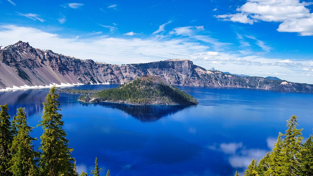
Over subsequent centuries, meteoric precipitation and groundwater accumulate within the collapsed volcanic depression, forming a caldera lake. The premier global exemplar is Crater Lake in Oregon, USA. Formed approximately 7,700 years ago during the climactic collapse of Mount Mazama, Crater Lake occupies an 8×10 km caldera and reaches a maximum depth of 594 meters (1,949 feet), making it the deepest lake in the United States and the ninth deepest on Earth. Because Crater Lake has no surface tributaries delivering terrigenous sediments, its water represents nearly pure rainwater and snowmelt, producing world-record optical clarity with Secchi depths exceeding 43 meters.
Maar Lakes: In contrast to colossal calderas, maar lakes form through violent phreatomagmatic eruptions. When ascending basaltic or trachytic magma encounters a shallow groundwater aquifer, the instantaneous flash-boiling of water to high-pressure steam triggers catastrophic subterranean phreatic explosions. These steam blasts shatter the overlying country rock, blasting a circular, flat-floored diatreme crater surrounded by a low tuff ring of ejecta. When volcanic activity ceases, groundwater fills the diatreme, producing a small, steep-sided, and remarkably deep maar lake (e.g., the Eifel maars in Germany and the Lake Nyos maar in Cameroon).
💧 Volcanological Catastrophe: Limnic Eruptions in Maar Lakes
Certain deep, meromictic volcanic maar lakes—such as Lake Nyos and Lake Monoun in Cameroon—accumulate massive quantities of dissolved magmatic carbon dioxide (CO2) in their monimolimnion. In 1986, Lake Nyos experienced a catastrophic limnic eruption: a sublacustrine landslide overturned the stratified water column, triggering rapid CO2 degassing that asphyxiated over 1,700 people and 3,500 livestock in adjacent valleys.
5. Limnological Succession and Trophic Evolution: From Glacial Oligotrophy to Senescence
Every lake on Earth is a geologically ephemeral feature bound to undergo a natural developmental trajectory termed limnological succession. From the moment an over-deepened glacial depression or volcanic crater fills with water, physical and biological processes inexorably operate to fill the basin with clastic sediments and biogenic detritus, ultimately transforming the open-water pelagic lake into a wetland bog, fen, or dry terrestrial meadow.
In its youthful pioneer stage, a newly formed post-glacial or caldera lake is profoundly ultra-oligotrophic. The freshly exposed, deglaciated bedrock or volcanic tuff yields negligible dissolved nitrogen and phosphorus. Water clarity is exceptionally high, dissolved organic carbon is near zero, and microbial communities are dominated by oligotrophic chemolithoautotrophs and slow-growing diatoms. Primary productivity is severely nutrient-limited, and fish communities are restricted to specialized coldwater stenotherms capable of surviving in nutrient-poor environments.
As the surrounding catchment undergoes terrestrial ecological succession—pioneer lichens and mosses yielding to nitrogen-fixing alders, boreal conifers, and deciduous forests—soil development accelerates. Organic humus accumulates on the watershed, enriching surface runoff with humic substances, dissolved organic matter, and bioavailable nutrients. The lake gradually transitions into a mesotrophic state: phytoplankton diversity expands, submerged macrophyte meadows colonize the littoral shelf, and zooplankton biomass multiplies.
Over millenary epochs, continuous sedimentary accumulation shoals the lake basin. As the hypolimnion volume shrinks, the ratio of water volume to surface area declines, warming the water column and accelerating internal nutrient remineralization. The lake progresses into a eutrophic stage characterized by dense summer algal blooms, extensive reed belts (Phragmites australis, Typha latifolia), and seasonal hypolimnetic anoxia. Finally, the encroaching littoral vegetation forms floating peat mats; the open water closes completely, entering the senescent dystrophic bog stage, cementing the terminal geological fate of the lacustrine basin.
6. Modern Cryospheric Degradation and Alpine Lake Vulnerability
Under the accelerating pressure of global climate disruption, alpine and proglacial lake systems are undergoing the most rapid transformations observed in human history. Glaciers across the European Alps, Tropical Andes, Himalayas, and Cascades are retreating at unprecedented rates, dramatically altering the hydrology, chemistry, and geomorphic stability of mountain watersheds.
As mountain glaciers vanish, they leave behind expanding proglacial lakes that initially buffer downstream river discharge by storing seasonal meltwater. However, as the glaciers melt completely past their peak water threshold, these high-altitude lakes lose their primary cryospheric nourishment, transitioning from meltwater-dominated systems to rain- and snowpack-dependent reservoirs subject to severe summer desiccation.
Furthermore, climate warming accelerates the degradation of high-altitude alpine permafrost, destabilizing the steep rock walls that frame glacial cirques and calderas. Massive rock avalanches—such as the catastrophic 2021 Chamoli event in the Indian Himalaya—increasingly plunge into alpine lakes, triggering catastrophic outburst waves and multi-hazard disasters. Simultaneously, warming water temperatures in pristine alpine lakes erode thermal barriers, facilitating the upward range expansion of invasive warm-water fishes and pathogenic chytrid fungi that decimate native high-altitude amphibians.
Mitigating these escalating mountain hazards requires advanced satellite radar interferometry (InSAR), automated real-time water-level sensors, and proactive engineering interventions—such as siphon drainage, controlled spillway trenching, and artificial tunnel excavation to lower lake levels before catastrophic dam breaches occur. Understanding the delicate balance of glacial and volcanic lacustrine dynamics is vital for protecting downstream communities and preserving the pristine freshwater reserves of the global highlands.